
Senegambia Bridge
Coordinates: 13 ° 30'56 " N , 15 ° 34'20" W.
| Senegambia Bridge | ||
|---|---|---|
 |
||
| Official name | Senegambia Bridge Trans-Gambia Bridge |
|
| use | Trans-Gambia Highway | |
| Crossing of | Gambia river | |
| place | at Bamba Tenda , North Bank Region and Yeli Tenda , Lower River Region | |
| construction | Reinforced concrete | |
| overall length | 1842 m | |
| width | 12 m | |
| Number of openings | 15th | |
| Longest span | 943 m | |
| Clear width | 70 m | |
| Clear height | 20 m | |
| vehicles per day | Cars and trucks | |
| building-costs | US $ 93 million | |
| start of building | 2015 | |
| completion | 2nd March 2019 | |
| opening | 20th January 2019 | |
| construction time | 4 years | |
| Status | New building | |
| toll | US $ 5 for passenger cars | |
| location | ||
|
||

The Senegambia Bridge is the only bridge in Gambia , apart from a few ferry connections, that connects the two parts of the country north and south of the Gambia River . At the same time, it makes the Trans-Gambia Highway , known in neighboring Senegal as the Trans- Gambienne , passable throughout.
history
Since 1956 there have been plans to build a bridge instead of the Bamba Tenda – Yeli Tenda ferry connection . To advance the plans, the states of Gambia and Senegal founded the Gambia River Development Organization in 1978 .
After the financing was clarified, the foundation stone was laid on February 20, 2015 . The construction work was largely in the hands of the Senegalese Arezki Group .
On January 21, 2019, the Senegambia Bridge over the river was opened in the presence of the Presidents of Gambia and Senegal, Adama Barrow and Macky Sall . The costs of 3.5 billion dalasi (approx. 62 million euros) were completely financed by the African Development Bank (AfDB).
description
The Senegambia Bridge is a toll bridge. It is open to traffic for approximately twelve hours a day from seven in the morning. Until July 2019, heavy goods traffic is still dependent on the ferry connection . For the time being, only light vehicles are allowed to use the bridge.
With a length of the bridge structure of 943 meters, it is one of the longest bridges far and wide. With the paved access ramps through the amphibious mangrove area , the length is 1758 meters. The total width of the bridge is 12 meters with a lane width of 7.50 meters and one lane in each direction. The prestressed concrete bridge structure has 15 bridge openings. These rest on 14 pillars, including 10 river pillars , as well as two abutments. The maximum passage height is given as “five floors” or a clearance height of 20 meters, so that most ships can pass through without problems. Other ships can also pass by after putting down masts. The fairway of the highest bridge opening is 70 meters wide between the ship deflectors , which consist of two rows of dolphins , which serve as ramming protection for the bridge piles.
95 percent of the workers employed in bridge construction came from Gambia or other African countries.

The vehicle ferry is to be replaced by the completed bridge

View from the top of the bridge to the south towards Soma, (Gambia)
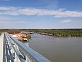
View from the top of the bridge to the north towards Farafenni


Web links
- Le Sénégal et la Gambie inaugurent le pont de Farafenni, après 40 ans d'attente jeuneafrique.com, from January 21, 2019
Individual evidence
- ↑ Project details at Arezki Group
- ↑ Senegambia Bridge belongs to Gambia: President Sall. Retrieved January 23, 2019 .
- ↑ eyeafrica.tv from January 18, 2019: Senegambia Bridge to be Opened to Light Traffic Only
- ↑ Gainako News: President Adama Barrow to Inaugurate TransGambia Bridge on Monday | Gambia News 24. In: gambianews24.com. Accessed January 28, 2019 .
- ↑ GTradio from January 26, 2019: The Senegambia Bridge
- ↑ Measure distances with google maps