Sengerema (district)
| Sengerema District | |
|---|---|
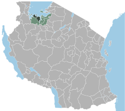
 Location of the Sengerema district in Tanzania |
|
| Basic data | |
| Country | Tanzania |
| region | Mwanza |
| surface | 8817 km² |
| Residents | 663,034 (2012) |
| density | 75 inhabitants per km² |
| ISO 3166-2 | TZ-18 |
Coordinates: 2 ° 35 ′ S , 32 ° 8 ′ E
Sengerema is a district of the Mwanza region in Tanzania , the administrative center is in the city of Sengerema . The district borders in the north and northeast on Lake Visctoria and the Ukerewe district on an island in it , in the southeast on the Missungwi district and in the southwest on the Geita region .
geography
The district is 8,817 square kilometers and has around 660,000 inhabitants (as of 2012). Of the total area, 5482 square kilometers are accounted for by Lake Victoria and 3335 square kilometers are land area. The district also includes islands in Lake Victoria, the largest of which are the islands of Maisome and Kome . The climate in Sengerema is tropical, Aw according to the effective climate classification . Rain falls in all months of the year. In the months of June, July and August it rains less than 20 millimeters each, from October to April 80 to 160 millimeters per month. In the capital, there is an annual average of 1059 millimeters of precipitation at 22.3 degrees Celsius.
Administrative division
The district is divided into 34 parishes (wards):
- Ibisabageni
- Nyamazugo
- Chifunfu
- Katunguru
- Kasungamile
- Nyamatongo
- Tabaruka
- Busisi
- Buyagu
- Igalula
- Kagunga
- Sima
- Nyakasungwa
- Kalebezo
- Nyehunge
- Kafunzo
- Bupandwa
- Katwe
- Maisome
- Kazunzu
- Lugata
- Nyakaliro
- Nyokasasa
- Buzilasoga
- Nyanzenda
- Bulyaheke
- Irenza
- Kasenyi
- Mwabaluhi
- Nyatukala
- Nyampulukano
- Nyampande
- Kishinda
- Igulumuki
population
The largest ethnic groups in the district are the Sumbwa and Zinza. The population increased from 303,897 in 1988 to 498,993 in 2002 and further to 663,035 in 2012. This makes Sengerema the most populous district in the region.
Facilities and services
- Education: There are 98 primary schools and 29 secondary schools in the district (as of 2019).
- Health: There is a hospital, four health centers and 38 pharmacies (as of 2019) to provide medical care for the population.
Economy and Infrastructure
|
 |
Nature reserves, sights
- Lake Victoria: More than half of the district area is the portion of Lake Victoria, which is the largest lake in Africa with 68,000 square kilometers.
- Rubondo National Park : The 456 square kilometer national park also occupies large parts of the island of Maisome. The park is known for its variety of water birds and butterflies.
Others
Sengerema has its own radio station. This was founded in 2012 with the help of UNESCO and was the first radio station in Tanzania to be run by women.
Web links
Individual evidence
- ↑ a b History | Sengerema District Council. Retrieved February 4, 2020 .
- ^ A b Tanzania Regional Profiles, 19 Mwanza Regional Profiles. (PDF) The United Republic of Tanzania, 2016, p. 17 , accessed on February 4, 2020 .
- ↑ a b Google Maps. Retrieved February 4, 2020 (de-US).
- ↑ Sengerema climate: Average Temperature, weather by month, Sengerema weather averages - Climate-Data.org. Retrieved February 4, 2020 .
- ↑ 2012 Population and Housing Census. (PDF) National Bureau of Statistics and Ministry of Finance, March 2013, p. 178 , accessed on February 2, 2020 .
- ^ Mwanza Region Socio-Economic Profile. (PDF) October 1997, p. 6 , accessed on February 4, 2020 .
- ↑ a b Statistics | Sengerema District Council. Retrieved February 4, 2020 .
- ^ Tanzania Regional Profiles, 19 Mwanza Regional Profiles. (PDF) The United Republic of Tanzania, 2016, pp. 96, 127, 129 , accessed on February 4, 2020 .
- ↑ a b Mwanza Region Investment Guide. (PDF) 2017, pp. 18–19 , accessed on February 4, 2020 .
- ↑ Mwanza Region Investment Guide. (PDF) 2017, pp. 8, 22 , accessed on February 4, 2020 .
- ^ Tanzania Trunk Road Network. Retrieved February 4, 2020 .
- ↑ Lake Victoria. Retrieved on February 4, 2020 (German).
- ↑ Tanzania in Figures 2018. (PDF) National Bureau of Statistics, 2019, p. 8 , accessed on February 4, 2020 .
- ^ Rubondo Island National Park - Tanzania Tourism. Retrieved February 4, 2020 .
- ↑ Radio Sengerema (Tanzania). Retrieved February 5, 2020 .
- ↑ Sengerema Radio :: Empowering local radio with ICTs. Retrieved February 5, 2020 .


