
Sherwood Island State Park
|
Sherwood Island State Park
|
||
 The east beach of Sherwood Island. |
||
| location | Westport (Connecticut) , Fairfield County (Connecticut) , USA | |
| surface | 0.96 km² | |
| Geographical location | 41 ° 7 ′ N , 73 ° 20 ′ W | |
|
||
| Setup date | 1932 | |
| administration | Dept. of Energy & Environmental Protection, State of Connecticut, The Nature Conservancy, Aquarion Water Company | |

Sherwood Island State Park is a state park in the US state of Connecticut on the territory of the township of Westport on the coast of Long Island Sound in the area of Greens Farms . It extends over an area of 96 hectares over beaches, wetlands and forest. It is bounded to the west by Sherwood Mill Pond and to the south by Long Island Sound. It is separated from the mainland by streams and marshland.
history
Several Fairfield colonists settled in the area in the 1640s . They were later referred to as the " Bankside Farmers ". They administered the area to which the then Fox Island called Sherwood Island belonged together. Daniel Sherwood settled on Fox Island in 1787 . In the 1800s he and his large family worked the higher areas in the west of the island. They ran a flour mill on Mill Pond . Several farmers worked together on the Machamux Salt Marsh . The inventor Henry Burr Sherwood also ran an onion plantation in the area. In the course of the 1860s the area was named "Sherwood's Island." The Gallup Gap Creek used to run north, south and east of the present park area and there is a belief that only the areas west of the creek belonged to Sherwood's Island. The stream was later dammed and diverted to power the mill.
When the Connecticut State Park Commission was formed in 1911, one of its primary goals was to acquire stretches of coastline and develop them as coastal parks . Albert Turner, a field secretary , walked the coast to find suitable areas. He was looking for areas of several hundred acres, undeveloped and of natural beauty. In addition, the areas had to have good beaches and be far enough away from cities to prevent sewage pollution. He concluded that Sherwood Island was the only suitable place in Fairfield County.
At that time, however, the land was owned by many different owners. The farmer William H. Burr Jr. from Westport acted on behalf of the state. In 1914 he bought two small parcels that also included a piece of beach. In doing so, he established Sherwood Island as Connecticut's first state park, although it would be another two decades before the park was actually put to use. In 1915 further parcels were acquired, so that finally 12 hectares were under protection. At that time there were over 7 km of beach in the park.
In 1923 additional pieces were purchased, but they were not connected to the rest of the park. Access to the park was through Westport's Burying Hill Beach . After local resistance, it was not possible to open the park until 1932.
On April 29, 1937, Governor Wilbur L. Cross signed two bills for $ 485,000 to buy more land. That was the breakthrough for the Connecticut Forestry Association , Fairfield County Planning Association, and their supporters. William H. Burr became known as the father of the park.
In the 1950s, the US Army Corps of Engineers built piers and enlarged both beaches. The park's beaches are now approximately 1.8 km long. The surf sorts three differently colored types of sand into delimited strips on the beach - red ( garnet group ), black ( magnetite ) and white ( quartz ). This is due to the different grain size and specific weight. In 1959 a pavilion and a bathhouse were built by the state. In 2002 a memorial for the victims of the terrorist attacks on September 11, 2001 was erected. The disaster could be seen from here.
free time activities
Recreational activities in the park include swimming, fishing, picnicking, diving, bird watching, kite flying, visits to the conservation center, and others. The Pavilion, the Badhaus, various kiosks, a first aid station as well as public toilets and drinking fountains are available for visitors.
Nature center
The First Nature Conservation Center was set up in the 1990s by Glenn D Jungsmann in an unused first aid and lifeguard building. Dochermann used the building as a starting point for nature tours and exhibited various preparations from local animals. In 1995 the Friends of Sherwood Island supported the nature center and set up an internship. In 2002 it was found that the building was unsafe and a new nature conservation center was established by 2009. The center currently offers various nature experiences in summer and shows information on nature and history in an exhibition.
September 11 Memorial

Sherwood Island State Park was chosen as the site of a memorial because on a clear day you can see the New York skyline from here. On September 11, 2001, visitors to the park watched the plume of smoke rising from the World Trade Center . Various victim support events were later held in the park. At the September 5, 2002 unveiling, the names of 149 victims who were Connecticut citizens were read out. The monument combines the durability of granite, the protective beauty of trees and the calm of the sea. The 2.7 m high polished granite stone bears the inscription: "The citizens of Connecticut dedicate this living memorial to the thousands of innocent lives lost on September 11, 2001 and to the families who loved them." Park entrances are from Connecticut Route 95 (I-95) on Connecticut Special Service Road 476 .
gallery

Looking east from the roof of the pavilion.
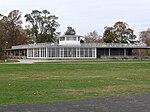
South pavilion.
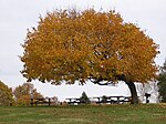
Picnic area in the west.
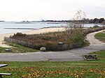
Beach in the west and "Protected Sand Dune Area"
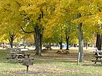
Picnic areas in the north-east


See also
literature
- George Penfield Jennings: Greens Farms, Connecticut: The Old West Parish of Fairfield. The Congregational Society of Greens Farms, 1933 (Reprinted: Modern Books & Crafts, 1971) OCLC 120383 .
- The William H. Burr Jr. Collection (B-112). Fairfield Historical Society, Fairfield, Connecticut.
Web links
- Sherwood Island State Park Connecticut DEEP
- Sherwood Island State Park Map Connecticut DEEP (PDF)
- Friends of Sherwood Island State Park
Individual evidence
- ^ Geographic Names Information System . United States Geological Survey.
- ^ State Parks and Forests : Funding, Recruiting, and Referrals. (PDF)
- ↑ George Penfield Jennings: Greens Farms, Connecticut: The Old West Parish of Fairfield . Modern Books and Crafts, 1971, pp. 2 ( books.google.com ).
- ^ Colonial Green's Farms . Friends of Sherwood Island. Retrieved February 14, 2013.
- ^ History of the Park . Friends of Sherwood Island. Retrieved February 14, 2013.
- ^ The Controversial Creeks . Friends of Sherwood Island. Retrieved February 14, 2013.
- ↑ a b c d The 23-Year War . Friends of Sherwood Island. Retrieved February 14, 2013.
- ↑ a b Connecticut Impressionist Art Trail signpost at the east end of the pavilion in Sherwood Island State Park.
- ↑ James W. Skehan: Roadside Geology of Connecticut and Rhode Island. Mountain Press Publishing Co., Missoula, Montana 2008, ISBN 978-0-87842-547-1 , p. 224.
- ^ A b Joseph Leary: A Shared Landscape: A Guide & History of Connecticut's State Parks & Forests . Friends of the Connecticut State Parks, Inc., 2004, ISBN 0-9746629-0-9 , pp. 45-46 .
- ^ History of the Nature Center . Friends of Sherwood Island. Retrieved May 22, 2014.
- ^ Nature Center . Friends of Sherwood Island. Retrieved May 22, 2014.
- ↑ Barnett D. Laschever, Andi Marie Cantele, Kim Grant: Explorer's Guide Connecticut . The Countryman Press, New York / Woodstock, ISBN 978-0-88150-824-6 , pp. 88 f . ( books.google.com ).
- ^ Connecticut's 9-11 Living Memorial . Connecticut DEEP. Retrieved February 18, 2013.
- ^ Secret Route List . In: Connecticut Roads . Kurumi. Retrieved April 15, 2014.