
Shibarikyu Park


The Shibarikyū Park ( Japanese 旧 芝 離宮 恩賜 庭園 , Kyū Shiba rikyū onshi teien ) is a park from the Edo period in the Minato district of Tokyo.
In the Kan'ei period (1624-1644) was the residence of the prince ( daimyō ) of Aizu , Katō Yoshiaki in the area . In 1678, the prince of Odawara and Chancellor ( Rōjū ) of the Shōgun , Ōkubo Tadatomo (1652-1712), took over the property and designed the garden he called Rakujuen . The changing garden, which is connected to the sea, is said to have been created by him. Later, the fiefdom ( Han ) Kishū used the site as a secondary residence until the Meiji restoration .
In 1871 the site fell to Prince Arisugawa, then in 1875 it came under the administration of the Ministry of the Interior as an alternative quarters for the imperial family in emergencies, and in 1876 finally as the “outer palace” ( 離宮 , rikyū ). The garden was badly damaged in the Kanto earthquake and was given to the city of Tokyo in 1924 . In 1962 the garden lost 4,800 m² due to the construction of the Shinkansen .
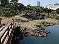
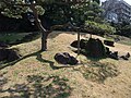
The small park surrounds a relatively large pond with three islands, Nakajima (which stands for the mythical Hōraijima ), Ukijima and Ōshima. A characteristic element is the dam over the West Lake (China) to the Nakajima, which can also be found in Koishikawa Kōrakuen . There are small hills, Ōyama , Karatsuyama (memory of the former fief of Okubo, Karatsu ). Traces of a place for training horses ( bakenjo ), a Wisteria trellis and an arbor complete this garden composition in a very small space. The park has also been surrounded by the water since the 1920s, but it is still a quiet place in the city. The park has been costing admission since 1979 and has been declared meishō (worth seeing) under the law for the protection of cultural assets .
To the north of the park, at the end of the Edo period, Egawa Hidetatsu set up a training area for cannons and rifles as part of national defense.
Characteristics
- Carrier: Tokyo Prefecture
- Opening: April 20, 1924
- Area: 43,070.53 m², including 5,453 m² of lawn
- Tree population: 1,928 trees (1995)
- Bush population: 3,059 bushes 852 m² bushland
- Lawn: 5,453 m²
- Facilities: archery practice area, kiosk
Image selection
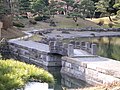
Dam over the West Lake
Nakajima

Garden party
Nine foot rise


literature
- Leaflet of the park
- Tōkyō-to (ed.): Kyū Shiba-rikyū onshi teien , in: Toritsu kōen gaido, 1995.
Web links
Coordinates: 35 ° 39 ′ 18 ″ N , 139 ° 45 ′ 31 ″ E