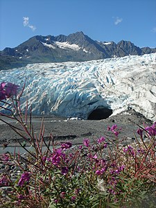
Shoup Glacier
| Shoup Glacier | ||
|---|---|---|
| location | Alaska ( USA ) | |
| Mountains | Chugach Mountains | |
| Type | Valley glacier | |
| length | 24 km | |
| Exposure | southwest | |
| Altitude range | 1500 m - 0 m | |
| width | ⌀ 2.2 km | |
| Coordinates | 61 ° 12 ′ N , 146 ° 34 ′ W | |
|
|
||
| drainage | Shoup Bay → Port Valdez → Prince William Sound | |
| particularities | Tidal glaciers | |
The Shoup Glacier is a glacier in the US state of Alaska 15 km west of Valdez .
geography
The 24 km long valley glacier has its nutrient area at an altitude of 1500 m in the Chugach Mountains on the eastern flank of Mount Shouplina 17 km north of Valdez. This borders on the nutrient areas of the Valdez and Columbia glaciers . The average 2.2 km wide glacier flows in a south-westerly direction and ends at the head end of Shoup Bay , a side bay of Port Valdez . The Shoup Bay State Marine Park stretches across the bay.
Web links
Commons : Shoup Glacier - Collection of Images, Videos, and Audio Files

