Lock position north

The security position north (Danish Sikringsstilling Nord ) is considered the best preserved fortification from the First World War in Europe. It was laid across North Schleswig from the North Sea to the Baltic Sea from 1916 , because the German army command feared a British attack on neutral Denmark . With the new demarcation of 1920, the area came to Denmark.
location
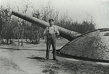
The securing position runs from the island of Rømø in the west about 50 km across the country to Hoptrup on the Little Belt . A northern outpost was at Aarösund. With almost 900 concrete bunkers, 40 batteries, two to four positions with several trenches, numerous signal stations and a track connection, the line was particularly well developed. When Nordschleswig became Danish in 1920, the facility appeared to the Danish government as a threat, as German troops could quickly take it from the south and direct it against Denmark in an emergency. The Danish military destroyed large parts of the facilities, and numerous bunker shelters were preserved. Bunkers located close to settlements or farms could not be blown up with the means available at the time without causing further destruction. Above all, the facilities at Gammelskov near Agerskov and at Andholm in the municipality of Øster Løgum are among the best-preserved fortifications from the First World War.
planning
In the course of the colonial crisis of 1905, Great Britain promised France to conquer the Kiel Canal from Denmark and tie up the German fleet in the Baltic Sea in the event of war . These plans became known to the German military leadership, which immediately dealt with the construction of a fortification to the north. An optimal defense option was crucial for the facility. That is why it was not created directly on the border at that time, but about 30 km south. In the following years, some maneuvers were held in the area, in which a possible British attack over Esbjerg was played out. Still, it lasted until 1916, when the First World War was long underway and had developed into a mass murderous trench warfare. Fearing that Denmark would take the side of Great Britain if the war went well and would allow her troops to march through, the construction of the north security position was started in late summer 1916.
Construction of the fortress line
The construction was led by an engineer battalion staff to which six engineer companies were subordinate. However, the heavy physical labor was imposed on military (and civilian) prisoners who were interned in barracks camps under difficult conditions. The punishment companies always consisted of 250 men. Some of these camps were previously prisoner of war camps. This has led to the belief that these prisoners of war were used for the work. However, this cannot be proven historically, as the German military adhered to the Hague Convention and did not use prisoners of war to build their own military facilities. These were mainly active in agriculture and civil infrastructure work.
In order to bring the building materials and workers to the construction sites as quickly as possible, special military tracks were laid and parts of the full-gauge and meter- gauge railways there ( Hadersleben and Apenrader Kreisbahn ), including the Branderup – Osterterp line , were expanded. Further pioneer tracks were laid out for wagon operation.
Roads and paths were also laid out, as were in some cases very long plank bridges over swampy meadows or smaller gorges. The trenches were marked and should have been dug by the soldiers themselves, but this never happened.
After the war
As mentioned above, after taking over the north-facing facilities , the Danish military tried to make them unusable. In fact, large parts of the bunkers and especially the cannon batteries were destroyed. Some of the latter still have impressive ruins (e.g. at Lerskov, Øster Løgum municipality). The shelters at Gammelskov and Andholm have been well preserved. The landowner wanted to keep the latter as historical monuments even then. The main shelter of the Aarösund beach battery upstream to the north (opposite the island of Årø ) was also very well preserved. Today it is interesting for tourists due to the wide view up to the bridges over the Little Belt near Middelfart . The facilities are now under monument protection and a project by the regional history society has led to an extensive inventory.
literature
- Ole L. Frantzen: Truslen om angreb - Danmark and Tyskland under 1. Verdenskrig . In: Mette Born (Ed.): I Krigens Fodspor - forsvarsbyggerier i Danmark . Kulturarvsstyrelsen , Copenhagen 2010, ISBN 978-87-91298-65-3 , p. 54–59 (Danish, kulturstyrelsen.dk [PDF; accessed June 11, 2020]).
- Mogens Scott Hansen: Sikringsstilling Nord - en tysk befaestningslinie I sonderjyland . Skov- og naturstyrelsen, Copenhagen 1992, ISBN 87-503-9807-5 .
- Hans Ole Mathiessen: Guide to sikringsstilling Nord . Sønderjyllands Amt, Amtsradet, Aabenraa 1994.
Web links
- Interactive map google maps
- Verdenskrigens spor (Danish) with photo documentation
- Sikringsstilling north. (No longer available online.) Archived from the original on January 7, 2017 ; accessed on June 11, 2020 (Danish).
- Sikringsstilling north. (No longer available online.) Archived from the original on September 28, 2016 ; accessed on June 11, 2020 (Danish).
- The Northern German Defense Line 1916-18 (security position north). (No longer available online.) Archived from the original on January 6, 2017 ; accessed on June 11, 2020 (English).
