Årø
| Årø | ||
|---|---|---|
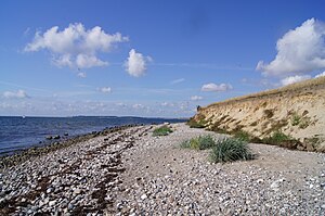
| The Baltic Sea forms a cliff coast on the south side of the island | ||
| Waters | Baltic Sea | |
| Geographical location | 55 ° 15 '45 " N , 9 ° 44' 51" E | |
|
|
||
| length | 4 km | |
| width | 3 km | |
| surface | 5.66 km² | |
| Highest elevation | 7.6 m | |
| Residents | 144 (January 1, 2020) 25 inhabitants / km² |
|
| main place | Årø | |
Årø (also Aarø , German Aarö ), not to be confused with Ærø , is a Danish island in the Little Belt . It is separated from the southern Jutland mainland by the 750 m wide Årøsund , but connected there by ferry. 144 inhabitants live on the island, which is four kilometers long and three kilometers wide (January 1, 2020). On the west side of the island of Årø is the town of the same name with the harbor for the ferry service and the diked system for the berths for sport and fishing boats. A DSRS lifeboat from Dansk Søredningsselskab is stationed at the harbor . The lighthouse "Årø Fyr" with a height of 13 m was built in 1905 to the southwest of Årø at a distance of 1000 m. This lighthouse was of the same type and was built parallel to the Årøsund lighthouse (height 10 m) by the metal construction company Julius Pintsch Söhne (Berlin or Fürstenwalde) in steel construction.
Årø belongs to the Association of Danish Small Islands . The island is mostly inhabited in the western and southern parts and is largely used for agriculture. On Årø there is a farm with Galloway cattle and a small wine-growing area ( Årø Vingård ), as the climate in the Danish South Pacific is mild and therefore suitable for viticulture. In the associated Ø-Butikken (island shop), not only commercial products but also those from the region are sold; There is also fish trade on the island. In addition, a tourism-oriented hospitality industry developed parallel to the existing campsite with around 100 parking spaces, about 1500 m from the ferry port in an easterly direction. Tourism and agriculture are important sources of income on the island.
Two particularly varied spits (sand hooks) have been placed under nature protection on the island : The Årø Kalv peninsula on the east side with a size of 30 hectares and the Store Korsø lagoon on the west side. The bird sanctuaries may not be entered during the breeding season (April 1 to July 15).
history
In the Middle Ages , the small island came into the possession of the Bishop of Schleswig . The residents were parish in the parish community ( Danish : Sogn ) Øsby Sogn ( German Oesby ). After the Reformation in the 16th century, the episcopal possessions were combined to form the secular office of Schwabstedt . Since its remaining parts were widely scattered throughout the Duchy of Schleswig , it was difficult to administer. It was not repealed until 1702 and Årø was again subordinated to the Harde Haderslev Herred in Haderslev Amt ( German Hadersleben ), to which the rest of Øsby Sogn was also subordinate. It was not until 1749 that the Danish king bought the ducal share of the island. By decree of November 2, 1750, it was incorporated into the royal share in the Duchy of Schleswig. The main postal connection from Haderslev and Årøsund to Assens ran via Årø .
The German-Danish War in 1864 led to the cession of the Danish fief Duchy of Schleswig and in personal union governed by the Danish royal duchies Holstein and Lauenburg from the Danish monarchy. In 1867 these finally became a Prussian province . Årø belonged to the newly created Hadersleben district as an independent rural municipality .
When the Baltic storm floods on November 13, 1872, 85 percent of the island was flooded. The water level reached about 3.5 m above normal mean high water. In Årø By a memorial stone commemorates the natural event.
In 1905 it got its own little church, which however remained an annex to Oesby. It is a Protestant parish. The ferry port Årøsund on the other side of the sound was connected to the Hadersleben circuit around 1900 , which made Årø increasingly interesting for tourists. After the referendum of 1920 , when North Schleswig was incorporated into the Kingdom of Denmark, Haderslev Herred and Haderslev Amt were re-established. With the Danish municipal reform in 1970 , Øsby Sogn became part of Haderslev Kommune in Sønderjyllands Amt , which in turn became part of the expanded Haderslev Kommune in the Syddanmark region with the next municipal reform in 2007 .
The "Årø Runddysse" megalithic complex is located on the island ; a severely disturbed dolmen (note: a heavily modified dolmen) .
Individual evidence
- ↑ a b statistics banks -> Befolkning og valg -> BEF4: Folketal pr. January 1st demands på øer (Danish)
- ↑ Geologisk set No. 205 Naturstyrelsen (Danish)
- ↑ Geologisk set No. 205 Naturstyrelsen (Danish)


