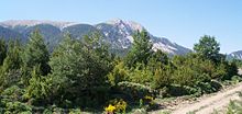
Sierra de Guara
The Sierra de Guara ( Sarra de Guara in Aragonese ) is a mountain range of the Spanish pre-Pyrenees . It is located north of the city of Huesca in the Spanish province of Huesca of the same name in the autonomous region of Aragon . The highest peak is the Tozal or Pico de Guara at 2,077 meters. In the eastern part is the Parque Natural de la Sierra y Cañones de Guara ( Natural Park of the Guara Mountain Range and Gorges ).
Web links
Commons : Sierra de Guara - Collection of images, videos and audio files
Coordinates: 42 ° 20 ′ N , 0 ° 30 ′ W
