
Silverado (California)
| Silverado | |||
|---|---|---|---|
Location in California
|
|||
| Basic data | |||
| State : | United States | ||
| State : | California | ||
| County : | Orange County | ||
| Coordinates : | 33 ° 45 ′ N , 117 ° 38 ′ W | ||
| Time zone : | Pacific ( UTC − 8 / −7 ) | ||
| Residents : | 1,945 (as of 2010) | ||
| Population density : | 11.3 inhabitants per km 2 | ||
| Area : | 172 km 2 (approx. 66 mi 2 ) | ||
| Height : | 112 m | ||
| Postcodes : | 92676 | ||
| Area code : | +1 714 | ||

Silverado is a community-free settlement in Orange County in the US state of California with 1945 inhabitants (2010).
geography
Silverado is located in Silverado Canyon in the Santa Ana Mountains , about 20 kilometers southeast of Irvine and 35 kilometers southeast of Newport Beach . The California State Route 241 runs at a distance of eight kilometers to the west.
history
The name Silverado is a word creation in the Spanglish language which denotes a place where silver is found and is a parallel word formation to Eldorado , a place where gold is found. It was founded in 1878. The residents' main livelihoods were initially working in silver mines and in the timber industry. Due to the exposed location in the Silverado Canyon, the place has been hit by natural disasters such as floods and bushfires.
Today Silverado is increasingly active in tourism. Irvine Lake , about five miles to the northwest, is a popular destination for birdwatchers and anglers. Hikers and mountaineers go on tours to the eastern peaks of Santiago Peak and Modjeska Peak .

SilveradoCanyon
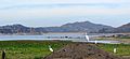
Irvine Lake
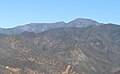
Santiago Peak

Modjeska Peak

_05.jpg)


Demographics
In 2010 there was a population of 1945 people, which means a decrease of 7.5% compared to 2000. The average age in 2010 was 44.4 years, well above the value in California, which was 32.1 years.