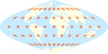
Sinusoidal projection

The sinusoidal projection is an area-true map network design (pseudo-cylinder mapping), which can represent the entire surface of the earth.
The equator and the central meridian are reproduced with approximately the same length and angle, but the greater the distance from the central meridian, the distortion increases significantly. Usually the prime meridian or the meridian 11 ° 5′30 ″ East is taken as the central meridian. In the latter case, the outer edge of the map goes through the middle of the Bering Strait .
All circles of latitude are shown as straight lines, with their length corresponding to the length of the circle of latitude. Meridians are shown as sine curves, the central meridian as a straight line. The meridian opposite the central meridian forms the (sinusoidal) outer edge of the map.
The network design is very easy to calculate, but it is not very clear and is therefore rarely used. The Mollweide projection or the similar-looking Hammer-Aitov projection , which both depict the earth's surface as an ellipse, are clearer.
Historical names for this projection are Mercator Equal Area , Mercator-Sanson Projection, and Sanson-Flamsteed Projection .
Formulas
- Down-illustration:
- Rear image:
- : East value
- : Great value
- : Radius of the underlying sphere
- : Latitude
- : Longitude
- : Central meridian (mean length of the projection)
Individual evidence
- ↑ a b c Sinusoidal. In: kartenprojektionen.de. Tobias Jung, accessed on August 5, 2018 .
- ^ John P. Snyder: Map Projections - A Working Manual . In: USGS Professional Paper. 1395, 1987, pp. 243-248.


