
Sittingbourne
| Sittingbourne | |||
|---|---|---|---|
 |
|||
| Coordinates | 51 ° 20 ′ N , 0 ° 44 ′ E | ||
| OS National Grid | TQ905635 | ||
|
|||
| Residents | 59,000 (as of 2010) | ||
| administration | |||
| Post town | SITTINGBOURNE | ||
| ZIP code section | ME9, ME10 | ||
| prefix | 01795 | ||
| Part of the country | England | ||
| region | South East England | ||
| Shire county | Kent | ||
| District | Swale | ||
| British Parliament | Sittingbourne and Sheppey | ||

Sittingbourne is a town in the north of the county Kent in England . It is the main town and administrative seat of the Borough of Swale , has about 59,000 inhabitants (as of 2010) and is conveniently located on the M2 motorway and the four-lane A249 about 60 km as the crow flies from London south of the Isle of Sheppey , from which it passes through the Channel The Swale is disconnected.
Traces of settlement can be found up to around 2000 BC. Prove ( Celts ). The Watling Street , one built in the first century AD across Britain running Roman road led through this place.

St. Michael in Sittingbourne

East window of St. Michael depicting the Last Supper
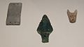
Finds from a Copper Age grave (2500 to 2100 BC) near Sittingbourne; from left to right: a stone arm protection plate, a copper dagger, a belt fitting


