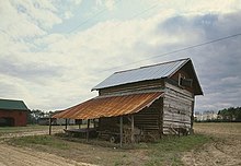
Smith Tobacco Barn
The Smith Tobacco Barn is a traditional tobacco drying barn from the first half of the 20th century in Dillon County , South Carolina . It was listed on the National Register of Historic Places in 1984 as the best preserved of its kind in the area .
use
Brightleaf tobacco was introduced in South Carolina in the 1880s and 1890s. These plants thrive on the sandy, loamy bottom of the Pee Dee and are smoke dried. The traditional sheds have one or two combustion chambers in which wood or coal was burned. In the 1950s, many sheds were converted to gas or oil firing as this allowed for better temperature regulation.
The tobacco leaves were placed over bars that were placed on horizontal beams in the shed. There were three phases of drying: the first phase dried the leaves at 40-43 ° C, in the second phase the temperature was increased to 54-57 ° C so that the leaves turned yellow. Finally the temperature was increased to 71-77 ° C to dry the stems.
description
The shed is rectangular. The gable roof is made of sheet metal and the base is made of bricks. The walls up to the eaves are made of sawn timber. The bars are notched together at the corners and the cracks are sealed with mortar. The gable ends are covered with horizontal weatherstrips. The small, rectangular doors in the gables can be opened to ventilate the interior. On the south and east sides there are post-supported canopies made of sheet metal that provide shade for the leaves to be rolled up. There are doors on the ground in the east and west. The name JL King and the date 1942 are carved into the corner stones. Inside, the shed was divided into five sections by wooden connecting beams. At the southern end there is a brick-built combustion chamber. Older photographs show that the firing was only switched to heating oil later.
When the shed was nominated for the National Register, it was no longer used as a tobacco shed, but was considered the best preserved tobacco shed in Dillon County and neighboring Marion Counties from between 1895 and the 1950s.
Individual evidence
- ^ Smith Barn. In: npgallery.nps.gov. National Register of Historic Places, accessed November 19, 2018 .
- ^ Smith Barn, Dillon County (near int. Of SC Sec. Rds. 155 & 22, Floydale vicinity). In: nationalregister.sc.gov. South Carolina Department of Archives and History, accessed November 19, 2018 .
- ^ Smith Barn. (PDF; 76.4 kB) National Register of Historic Places Inventory Nomination Form. In: nationalregister.sc.gov. United States Department of the Interior. Heritage Conservation and Recreation Service, October 3, 1984, accessed November 19, 2018 .
- ↑ Edwin P., Jr. Rogers, Edmonds, Mary W .: Flue-cured Tobacco Production Properties (MPS) ( English , PDF) In: National Register of Historic Places Inventory - Nomination Form . National Park Service. June 12, 1984. Accessed on June 21, 2009. ( Page no longer available , search in web archives ) Info: The link was automatically marked as defective. Please check the link according to the instructions and then remove this notice.
- ↑ a b Smith Barn ( English , PDF; 76 kB) In: National Register of Historic Places Inventory - Nomination Form . National Park Service. Retrieved May 10, 2009.
- ↑ a b Nancy Pittenger, Chandler, Andrew W .: Photographs and Written Historical Descriptive Data (Architectural Data Form, p. 3) ( English , PDF) In: Historic American Building Survey . National Park Service. April 5, 1988. Accessed on June 21, 2009. ( Page no longer available , search in web archives ) Info: The link was automatically marked as defective. Please check the link according to the instructions and then remove this notice.
- ↑ Jack Boucher: Smith Tobacco Barn, 1/4 mile south of Secondary Road 17-34 & 1/2 mile, Dillon vicinity, Dillon County, SC ( English ) In: Historic American Building Survey (Photographs) . National Park Service. March 1987. Retrieved May 10, 2009.
Coordinates: 34 ° 20 ′ 32 " N , 79 ° 15 ′ 10" W.
