
Soilasee
| Soilasee | ||
|---|---|---|

|
||
| The Soilasee in summer | ||
| Geographical location | Oberammergau municipality , Garmisch-Partenkirchen district , Upper Bavaria , Germany | |
| Tributaries | nameless, periodically | |
| Drain | without | |
| Data | ||
| Coordinates | 47 ° 35 '13 " N , 11 ° 6' 45" E | |
|
||
| Altitude above sea level | 1398 m | |
| length | variable | |
| width | variable | |

The Soilasee (also Soilasee ) is a natural, periodic lake that usually falls completely dry in summer. It is located in a depression at the foot of the Laber and Ettaler Manndl , which is probably a sinkhole shaped over the Ice Age .
The lake can be reached via the hiking trail from Oberammergau to Laber. About 400 m northeast of the lake and about 60 m below is the Soilaalm , which is cultivated in summer .
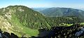
Soilasee seen from the Ettaler Manndl. Left the lab.
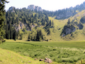
Soilasee that fell dry in midsummer 2018. In the background, the summit rocks of the Ettaler Manndl.
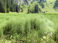
Horsetail on the bottom of the dried out Soilasee.


Web links
Commons : Ammergau Alps - Collection of images, videos and audio files
Individual evidence
- ↑ Explanations of the Geological Map GK25, sheet Oberammergau, http://www.lfu.bayern.de/gdi/dls/daten/gk25/gk25_8432.zip