
Lock point Rothenbrunnen

The Rothenbrunnen blocking point (Army designation no. 1207) was a rear defensive position for the Swiss Army . It is located at the northern exit of Domleschg in the Engnis north of Rothenbrunnen .
The lock was built in 1942 by civil companies and is considered a military historical monument of national importance. She belonged to Mountain Division 12 . With the Army 95 the fortresses were shut down and released from secrecy in 2006.
Strategic location


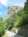
A north-south traffic axis that has been important since Roman times runs through Domleschg . In the Middle Ages , the passage on the right bank of the “Via Calanca” (also called “Römerweg”) near Rothenbrunnen with the castles Hochjuvalt (built in 1216) and Innerjuvalt (also Oberjuvalt, built in 1243) was paved.
During the Second World War , the Rothenbrunnen barrier was built on the same site. The Ravetsch rock works on the left (A 7801) and Juvalta on the left (A 7803) are located directly on the historic “Via Calanca” traffic route. In 1915, sappers from Vogelsang to Rothenbrunnen created a new path that replaced the old path. During the Second World War, interned Poles continued to expand the road ( Polenweg ).
assignment
The blocking point had the order to block the passage of an enemy coming from the north or south in the Rothenbrunnen area. While with most of the suspensions it was clear from which side the opponent was to be expected, both were possible in Rothenbrunnen.
The operational order of the commander of Mountain Brigade 12 (from 1962 Mountain Division 12) of February 20, 1944 read: "The Beverin combat group holds the Rothenbrunnen roadblock from north and south".
First, an enemy who had broken through from the south had to be blocked from entering the main axis of incidence to the core of the Reduit (Gotthard). Second, an enemy from the north had to be expected who could break through the fortress bar at Sargans. Third, enemy air landing operations could take place north of the barrier in the plain between Reichenau, Bonaduz and Rhäzüns .
The barrier and the infantry and tank obstacles had to be created accordingly:
Fortress construction
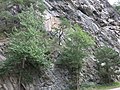
The main barrier (Juvalta left A 7803) was built into the rock head on which the Hochjuvalt ruins are located at the narrowest point of the valley between the Domleschg in the south and the Rhäzüns / Bonaduz plain in the north. The plant was designed for 30 men and supplies for three months.
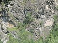
The infantry and tank obstacles in the valley floor were integrated into the medieval barrier wall below Hochjuvalt, in which the concrete humps connect directly to the quarry stone walls. Juvalta on the left was armed with two machine guns and an infantry cannon (later a 9 cm anti-tank gun). The counterwork Juvalta on the right (A 7802) had a machine gun and an anti-tank cannon (later a 9-cm anti-tank cannon).
The second barrier line is located north of the main barrier at Ravetg and was armed with a total of three machine guns (Ravetsch left A 7801, Ravetsch right A 7802). Ravetsch left had a switchboard with a connection to the Juvalta plant on the left.
With the Army 61 in 1962 ( Cuban Missile Crisis ) the old 4.7 cm cannons were replaced by modern 9 cm anti-tank cannons and the water-cooled model 1911 machine guns by modern machine guns model 1951 with interchangeable barrels. Since the 1980s, the locking point has received fire support from a modern 12 cm twin mine thrower.
Until 1985, the ammunition chamber of the Juvalta Fortress had a vault ("Depôt No. 4") of the Swiss National Bank with two armored doors on the left, with a storage capacity of 140 tons of gold. This was outside the redoubt, while three more secret gold safes were built into redoubt fortresses.
After the opening of the N13 with the Isla-Bella road tunnel in 1989, the last retrofits at Swiss infantry works were the two fortresses Juvalta left and Juvalta right in 1990 so that they could act on the anti-tank barrier over the new motorway with their two anti-tank cannons and a machine gun. Juvalta on the left received a new entrance at the Polenweg instead of the laborious high entrance. The tank barrier from 1941 was extended so that the N13 could be blocked and explosive charges were installed in the Isla Bella tunnel.
Plant locations and armament

The blocking point No. 1207 Rothenbrunnen from 1995 comprised four infantry works in rock caverns, two anti-tank cannons and six machine guns, five modern ASU shelters, three loaded explosive objects in Polenweg, “Italian Street” and in the motorway tunnel, eight street barricades, one of which was a “steel spider” on the Autobahn, a rail barricade in the RhB route. The terrain armor obstacle GPH is broken through by the railway line, the road, the Hinterrhein and the motorway.
- Ravetsch infantry plant on the right A 7800: Mg ⊙
- Infantry blockhouse Ravetsch left A 7801: 2 Mg ⊙
- Juvalta infantry plant on the right A 7802: Mg / Pak from 1989 ⊙
- Juvalta infantry plant left A 7803: Pak, 3 Mg ⊙
- GPH Polenweg Juvalta North ⊙
- GPH Polenweg Juvalta South ⊙
- Explosive object street Ravetsch right ⊙
- Explosive object street Ravetsch left ⊙
- Explosive objects in RHB-Trasse Juvalta right ⊙
- Explosive objects under Hauptstrasse Juvalta on the right ⊙
- Panzersperre Hauptstrasse Juvalta on the right ⊙
Notches IW Ravetsch A 7801

Notch IW Ravetsch A 7801

old and new entrance IW Ravetsch A 7801

old entrance IW Juvalta A 7803
Entrance Juvalta A 7803


Pro Castellis and Via dei Castelli
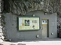
The Hochjuvalt castle and dam as well as the Rothenbrunnen blocking area were restored by the Pro Castellis association over many years of painstaking work. The association is committed to the research and preservation of historical monuments for posterity and supports historical research projects. It maintains over 30 historical military monuments in several cantons (BE, GL, GR, SG, ZH).
In 1986, Pro Castellis created a teaching aid on castles and the “Domleschg Castle Trail” for schools in Graubünden, which is used intensively by school classes. With the “Via dei Castelli” project, this didactic project is to be made accessible to all interested parties as an attractive cultural hike and inaugurated in 2018.
Hochjuvalt 1216 and Polenstrasse GPH Süd 1942
Hochjuvalt and Scharte IW Juvalta

Northern dam 1216 1942

South dam 1216 1942


literature
- Peter Baumgartner , Hans Stäbler: Fortified Graubünden. Wolves in sheep's clothing. Military History Foundation Graubünden, Chur 2006. New edition Verlag Desertina, Chur 2016, ISBN 978-3-85637-485-3 .
- Silvio Keller, Maurice Lovisa, Thomas Bitterli: Military monuments in the canton of Graubünden. Federal Department of Defense, Civil Protection and Sport (Ed.), Bern 2003.
Web links
- Little porcupine: Rothenbrunnen barrier
- Photo of the building: Hochjuvalt restoration
- Pro Castellis: Video locking point Rothenbrunnen
Individual evidence
- ^ Silvio Keller, Maurice Lovisa, Thomas Bitterli: Military monuments in the canton of Graubünden. Federal Department of Defense, Civil Protection and Sport (Ed.), Bern 2003
- ^ "Via Calanca" (GR 9.1 (Chur -) Domat / Ems - Thusis / - Sils iD) is of national importance according to the inventory of historical traffic routes in Switzerland : Historic traffic routes in Switzerland: GR 9.1. Domat / Ems-Thusis ( page no longer available , search in web archives ) Info: The link was automatically marked as defective. Please check the link according to the instructions and then remove this notice.
- ↑ Crestawald Fortress Museum: Lock Rothenbrunnen
- ↑ Oberland Fortress: Rothenbrunnen blocking point
- ↑ Fortress Museum Lock Trin: Lock 1207 Rothenbrunnen
- ^ Pro Castellis: Castle and dam Juvalt 1216
- ^ Pro Castellis: Via dei Castelli
- ↑ Nature trail 1: Rothenbrunnen closure point with fortress Juvalta on the left A 7803
- ↑ Nature trail 2: The dam from 1216 and the tank barrier from 1942
- ↑ Educational trail 3: The Castle of the Lords of Juvalt from 1216
- ↑ Fortified Graubünden 1941
Coordinates: 46 ° 46 '30.6 " N , 9 ° 24' 53.2" E ; CH1903: seven hundred and fifty thousand nine hundred and twelve / 182345