
Haunted hole
| Haunted hole | ||
|---|---|---|
| Geographical location | District of Mecklenburg Lake District | |
| Location close to the shore | Goods (Müritz) | |
| Data | ||
| Coordinates | 53 ° 27 '4 " N , 12 ° 43' 17" E | |
|
||
| Altitude above sea level | 62.1 m above sea level NHN | |
| surface | 5.7 ha | |
| length | 480 m | |
| width | 150 m | |

The Spukloch is a flat lake in the urban area of Waren (Müritz) northeast of the Müritz bank in Mecklenburg-Western Pomerania.
geography
The inflow and outflow of water is located 250 meters northeast of the Müritz near the Müritzhof belonging to Waren (Müritz) in the west of the Müritz National Park . A deciduous forest area adjoins the land bridge to Müritz to the west of the bank . Especially in the south and north there are moist, unforested areas. The haunted hole has a maximum size of 480 by 150 meters, the area takes up 5.7 hectares. The water level is 62.1 m above sea level. NHN and is thus on the level of the larger neighboring lake.
Geologically the Spukloch surrounded by Seesandflächen a setback terrace . There is a small clay pool area to the southeast.
history

Due to fluctuations in the water level, including changes in the height of the mill dam and the regulation of the Elde , the haunted hole was temporarily part of the Müritz.
A 280 hectare nature reserve Müritzhof was already designated on the Müritz terrace in 1931. In 1949 the Spukloch became part of the 48 km² large nature reserve east bank of the Müritz , which was one of the largest protected areas in the GDR. Since 1990 the body of water has belonged to the Müritz sub-area of the Müritz National Park.
Flora and fauna
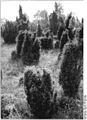
The Flachsee has almost all of the ground lawn and diving corridors (both aquatic plants ). In the vicinity of the water in the Spuklochkoppel there is one of the last juniper heaths in the state of Mecklenburg-Western Pomerania, which developed after 1940 from a guarding area after decreasing grazing and care intensity. To preserve the landscape, this area is now grazed with mountain cattle and Gotland sheep. The Fjäll cattle were brought in as early as 1969.
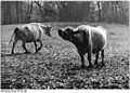
Fjäll cattle in the haunted paddock (1982)

Wet meadow near the haunted hole (1990)
Juniper heather near the haunted hole (1990)


Lower parts of the haunted paddock are temporarily flooded in winter and dry off again in summer.
Plant species found in the periphery of the lake include: Baltic gentian, marsh gentian and orchid , broad-leaved orchid . The haunted hole is part of a crane resting place in the shallow water areas east of the Müritz. Up to 8500 cranes a year fortify themselves in this area on their autumn bird migration southwards.
See also
Individual evidence
- ↑ a b c d Mecklenburg-Western Pomerania Ministry of the Environment (ed.): The nature reserves in Mecklenburg-Western Pomerania , Demmler Verlag, Schwerin 2003, ISBN 3-910150-52-7 , p. 586 ff.
- ↑ Fred Ruchhöft: The water level of the "Upper Lakes" in Mecklenburg in the Middle Ages and early modern times in: Archaeological reports from Mecklenburg-Western Pomerania, Vol. 6, 1999
- ↑ Müritzhof Landscape Care Farm on mueritz.de
- ↑ Picture with description from a picture gallery on uni-oldenburg.de
- ↑ Müritz National Park News October 2007 (PDF file)