
Lobesrode (desert)
Lobesrode was first mentioned in 1216 as Lovesrot and was an abbey village of the Kaufungen monastery in the Söhre near Kassel, which was abandoned between 1347 and 1352 because of the plague epidemics . It is known that the St. Juliane Chapel was first mentioned in a document in 1304, but was probably of an older date. The chapel was located on an early medieval high path, which was called the Breiter Weg , and was connected to an inn for many years as a place of pilgrimage . From 1550 the name and the story disappeared from oral traditions.
The ruins of the Glockenborn and the Stückkirchen ruins are still preserved today. The district is therefore called the forest town of Stückkirchen today and is a tourist destination for hikers.
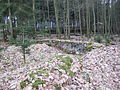
View over the ruin of Stückkirchen

Remains of the wall from the Stückkirchen ruins


Historical place names
Lovesrot, (1216); curia in Lovesrode, (1219); in parvo Lubesrode, (1318); capella s. Juliane sita in monte Lubisrade in silva quadam prope opidum Lichtenauwe, (1431); Hessenhayn bober Lubesrade (Charterhouse)
literature
- Georg Landau : Historical-topographical description of the desolate localities in the Electorate of Hesse and in the grand-ducal Hessian parts of Hessengaue, Oberlahngaue and Ittergaue (= journal of the Association for Hessian History and Regional Studies. Supplement 7, ZDB -ID 200295-4 ). Fischer, Kassel 1858, p. 57 .
- Heinrich Reimer: Historical local lexicon for Kurhessen (= publications of the historical commission for Hesse and Waldeck. Vol. 14, ISSN 0342-2291 ). Elwert, Marburg 1926, p. 308.
- Klaus Sippel: Desolation around Wellerode. Archaeological traces of disappeared villages and churches as sources for the settlement history of the Söhre in the Middle Ages. In: Municipality of Söhrewald (ed.): 650 years of Wellerode. 1351-2001. Community council of the community of Söhrewald, Söhrewald 2001, pp. 1–16.
Web links
- Lobesrode desert, Kassel district. Historical local dictionary for Hessen. In: Landesgeschichtliches Informationssystem Hessen (LAGIS).
- The St. Juliane Chapel at Opencaching
- Image of the plaque for the historical place
Individual evidence
- ↑ Lobesrode desert, Kassel district. Historical local dictionary for Hessen. In: Landesgeschichtliches Informationssystem Hessen (LAGIS).
- ↑ It was first incorrectly referred to as St. Juliane by G. Landau in 1858 or 1842 , which can still be read on various maps today. In the tradition, Stückkirchen is never referred to as the Julian Chapel, but always only as the Hessenhain Church.
Coordinates: 51 ° 13 '48.7 " N , 9 ° 37' 2.3" E