
St. Augustine (Trinidad)
| St. Augustine | ||
|---|---|---|
|
Coordinates: 10 ° 39 ′ N , 61 ° 24 ′ W St. Augustine on the map of Trinidad and Tobago
|
||
| Basic data | ||
| Country | Trinidad and Tobago | |
| Regional Corporation | Tunapuna-Piarco | |
| Residents | 4844 (2011, without students) | |
| Detailed data | ||
| City structure | 5 communities | |
| prefix | 662, 663, 645, 826 | |
| Time zone | UTC −4 | |
 |
||

St. Augustine is a city in Trinidad and Tobago . It is located in the east-west corridor in the Tunapuna-Piarco region .
location
St. Augustine is located in the north of the island of Trinidad, in the middle of the East-West Corridor , the metropolitan region of the state capital Port of Spain south of the Northern Range from west to east . Since Port of Spain is bounded in the north by the Northern Range and in the south by the Caroni Swamp , the city expanded to the east over time. The resulting east-west corridor is so densely populated that in the past independent cities merge into one another and now have the character of districts of the capital agglomeration. However, they are still formally independent. The smallest administrative unit in Trinidad are the communities . St. Augustine consists of the communities of Mount St. Benedict, St. Augustine, St. Augustine South, St. John's Village, and Santa Margarita. The city goes counter-clockwise and starts in the west over to St. Joseph , Valsayn , Curepe , Macoya, Tunapuna and Maracas. The problem with a geographical assignment is that a community can belong to different cities, constituencies and postal areas. The community of Santa Margarita, for example, politically belongs to the city of St. Augustine, but to the postcode area of Tunapuna and the constituency of Curepe.
economy
The largest employers in the city are the educational institutions, especially the UWI. Industry has settled along the Churchill Roosevelt Highway , the most important east-west route in Trinidad. There are companies in the food and light industry for local needs and for supplying the neighboring islands.
Facilities
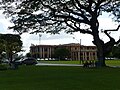
St. Augustine is one of the four campuses of the University of the West Indies with approximately 18,000 students enrolled. There are u. a. houses the world's first research center for tropical agriculture and the Seismic Research Center, a specialist institute for volcanic and seismic activities in the English-speaking Caribbean. Other educational institutions in St. Augustine include:
- The Hugh Wooding Law School named after Hugh Wooding , one of three law schools in the Caribbean Commonwealth of Nations that are allowed to issue legal education certificates .
- The School of Accounting and Management , a branch of Anglia Ruskin University .
From 1912 the Abbey of Mount Saint Benedict was built in the Northern Range above St. Augustine by Benedictine monks from Brazil , a building complex consisting of a Catholic church, monastery, seminary, yoghurt factory, drug rehabilitation center and guest house.
St. Augustine has a private hospital. Resurface Radio , a private radio station, is based in the city . St. Augustine FC plays in the Premier League of the Trinidad & Tobago Women's League Football.
Personalities
- Ian McDonald (born 1933), writer
gallery

St. Augustine

Mount St. Benedict
UWI campus

