St. Francis Bay
| St. Francis Bay | ||
|---|---|---|
|
|
||
| Coordinates | 34 ° 10 ′ S , 24 ° 50 ′ E | |
| Basic data | ||
| Country | South Africa | |
| Eastern Cape | ||
| District | Sarah Baartman | |
| ISO 3166-2 | ZA-EC | |
| local community | Kouga | |
| Residents | 4933 (2011) | |
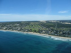
St. Francis Bay ( Afrikaans : St. Francisbaai ) is a place in the province of Eastern Cape in South Africa . In 2011 it had 4,933 inhabitants.
The place is on the Garden Route between Knysna and Port Elizabeth . The national road N2 runs around 20 kilometers north. St. Francis Bay is part of the Kouga Ward, Sarah Baartman District .
Originally, Khoikhoi lived in this area . The first European in St. Francis Bay was Diogo Pereira Botelho in 1537. In 1575, the Portuguese explorer Manuel de Mesquita Perestrello gave St. Francis Bay its name after the monastery in his hometown of Santarém . In 1765 the first Voortrekkers settled in the bay.
St. Francis Bay is known as a water sports paradise. The four kilometer long beach offers excellent conditions for surfing. From August to October you can watch whales here. St. Francis Bay crosses an eight kilometer long canal system of the Kromme River . The temperatures are between 12 ° C in winter and 30 ° C in summer.
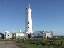
Cape St. Francis is located ten kilometers south of St. Francis Bay. The lighthouse there was completed in 1878. It is the tallest lighthouse in South Africa and has been listed as a historic building. There is also a weather station and a breeding station for African penguins .
Web links
- Homepage St. Francis Bay (English)
- Information about St. Francis Bay (English)
- History of St. Francis Bay (English)
Individual evidence
- ↑ 2011 census , accessed January 13, 2016


