
St. Matthew Island
| St. Matthew Island | ||
|---|---|---|
 |
||
| Waters | Bering Sea | |
| Geographical location | 60 ° 25 ′ N , 172 ° 46 ′ W | |
|
||
| length | 54 km | |
| width | 6 km | |
| surface | 357.05 km² | |
| Highest elevation | Sugarloaf Mountain 450 m |
|
| Residents | uninhabited | |
 |
||

The St. Matthew Island ( English St. Matthew Island ) is an uninhabited island in the Bering Sea belonging to the US state of Alaska . It is located in the Bethel Census Area .
geography
St. Matthew is comparatively isolated about 295 km west-north-west from Nunivak . The elongated island is 54 km long, but only 1 to 6 km wide; the highest point is around 450 meters above sea level. It has an area of 357.05 km² , making it the 43rd largest island in the United States .
The interior of the island is characterized by subarctic tundra . The hilly landscape is criss-crossed by wide river valleys. The coast has a mix of steep slopes, cliffs and beaches. Cape Upright , at the southernmost end, has cliffs a little more than 300 meters high . The highest point is Sugarloaf Mountain at 450 meters.
5 km north of St. Matthew across the four kilometers wide Sarichev Strait is the small Hall Island , 13 km south of St. Matthew the small Pinnacle Island .
natural reserve
The entire island is designated a nature reserve and part of the Alaska Maritime National Wildlife Refuge .
Wildlife
The only mammals at the moment are arctic foxes and voles , and polar bears occasionally come across the sea ice. A reindeer population released in the 1940s has since declined . On the island there is, among other things, a breeding colony of crested hawks , a medium-sized alken bird , which during the breeding season has a striking orange-red beak and a head of feathers reaching forward.
In a small lake on the island there are specimens of the king salmon ( Oncorhynchus tshawytscha ) and the arctic char .
- Flora Fauna
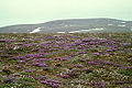
Tundra on St. Matthew with the purple pointed keels ( Oxytropis nigrescens )

Zwergalken ( Aethia pusilla ) on St. Matthew


Web links
- St. Matthew Island in the United States Geological Survey's Geographic Names Information System
- Portrait and satellite images on oceandots.com ( Memento from December 23, 2010 in the Internet Archive ) (English)
Individual evidence
- ↑ Block 1045, Block Group 1, Census Tract 1, Bethel Census Area, Alaska (English)
- ^ Anthony J. Gaston and Ian L. Jones: The Auks . Oxford University Press, Oxford 1998, ISBN 0-19-854032-9 , p. 245