Stanton Drew
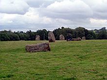
The Stanton Drew Stone Circles are just outside the village of Stanton Drew, in the Chew Valley, north of the Mendip Hills , about 8 miles south of Bristol in Somerset , England .
description
- The largest stone circle is the "Great Circle". With a diameter of 113 m it is the second largest stone circle in England (after Avebury ). It probably consisted of 30 stones, 27 of which have survived. It was surrounded by a now-filled trench of a henge about 135 m in diameter and seven meters wide. A 40 m wide entrance was on the northeast side. No surrounding wall was detected.
He was drawn to John Aubrey (1626–1697) and William Stukeley (1687–1765). One stone avenue leads to the northeast of the Great Circle, in the direction of the Chew River, and a second one reaches it from the northeast circle.
- The northeast circle is 30 m in diameter and probably consisted of ten or more stones, eight of which have survived.
- The southwest circle has a diameter of 43 m and 12 preserved stones.
The environment
The menhir "Hautville's Quoit" lies in the north across the river. A large stone near the Hautville Quoit Farm, lying since at least the middle of the 17th century, but originally standing upright, was described by W. Stukeley in 1723 as a 13 m long menhir. Today it is about half as long as pieces of the stone have occasionally been broken off to mend the roads. W. Stukeley also reports the presence of another stone.
Further west in the garden of the "Druid's Arms Public House" is a cove made of two menhirs with a stone lying in between. The stones are mineralogically different from those of the nearby stone circles. They have heights of 4.4 m, 3.1 m and 1.4 m.
Geophysical survey
The geophysical investigations from 1997 showed the surrounding ditch and nine concentric post rings with a diameter of 23 to 94 m in a large stone circle. More than 400 pits one meter wide and 2.5 m apart lay in the rings.
Geophysical work changed the traditional view of Stanton Drew as a surface monument , and the Great Circle as a whole is now considered to be one of the greatest late Neolithic monuments. Analogous to the Timber Circles of Woodhenge , Durrington Walls and The Sanctuary , it is assumed that the pits either contained posts connected to one another by a lintel or (more likely) free-standing posts. The post holes in the nine concentric rings were up to one meter in diameter.
A small ring of eight stones and four pits in the middle has been identified nearby. Another ring, 43 m in diameter, consisting of 12 stones, stood in the southwest. A magnetometer survey of the menhirs in the garden of the Druid's Arms Public House in 2009 showed that these stones were almost 1000 years before the stone circles that date back to 2800 BC. To be dated. The conclusion was that they probably belong to the portal or facade of an abandoned megalithic complex.
literature
- Aubrey Burl: The stone circles of Britain, Ireland and Brittany . Yale University Press 2000, ISBN 0-300-08347-5 .
- Homer Sykes: Mysterious Britain - Fact and Folklore George Weidenfeld & Nicolson Ltd. 1993 p. 43
Coordinates: 51 ° 22 ′ 4.1 ″ N , 2 ° 34 ′ 30.9 ″ W.

