
Sieverner See
| Sieverner See | ||
|---|---|---|

|
||
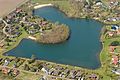
| Sieverner See, view from the northeast, May 2012 | ||
| Geographical location | Sievern , Cuxhaven district , Lower Saxony | |
| Places on the shore | Sievern | |
| Location close to the shore | Bremerhaven | |
| Data | ||
| Coordinates | 53 ° 39 '3 " N , 8 ° 37' 1" E | |
|
||
| Altitude above sea level | 3 m above sea level NN | |
| surface | 2.4 ha / | |
| length | Max. approx. 260 m | |
| width | Max. approx. 200 m | |
| Maximum depth | 13 | |
| Middle deep | 8th | |

The Sieverner See is an artificial bathing lake in the area of the village of Sievern in the city of Geestland in the Lower Saxony district of Cuxhaven .
Geographical location
The lake was named after the center of the village of Sievern, which lies on average about 1 km to the west. A residential area belonging to Sievern lies on its banks around the still water , through which the “Sieverner See” road, named after the lake, leads. The Heidenschanze ring wall is located around 700 m northeast of the lake and the Pipinsburg fortification is around 900 m north-northwest .
Description of the lake
The approximately 2.4 hectare lake is a maximum of 200 m wide in west-east direction and up to 260 m long in north-south direction and lies at about 3 m above sea level. NN . It was created during the construction of the Federal Motorway 27 about 3 km to the east . For swimming there is a sandy beach with a lawn on the north-west bank. The bathing operation is monitored by the local group Langen of the DLRG , for which a guard station has been available since 1984. There is also a kiosk, toilets and showers on the lake.
Picture gallery
Aerial view from the south, May 2013

Aerial view from the southeast, with residential area


See also
Web links
Individual evidence
- ↑ a b Overview of the Sieverner See in the bathing water atlas Lower Saxony
- ↑ a b c Sieverner See on seen.de
- ↑ a b Data on Lake Sievern in the Lower Saxony bathing water atlas
- ↑ Topographic map Sieverner See ( memento of the original from March 4, 2016 in the Internet Archive ) Info: The archive link was inserted automatically and has not yet been checked. Please check the original and archive link according to the instructions and then remove this notice. , on natur-erleben.niedersachsen.de
- ↑ DLRG local group Langen