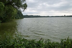
Glauchau reservoir
| Glauchau reservoir | |||||||||
|---|---|---|---|---|---|---|---|---|---|
| Glauchau reservoir, north bank, looking south | |||||||||
|
|||||||||
|
|
|||||||||
| Coordinates | 50 ° 48 ′ 33 " N , 12 ° 31 ′ 17" E | ||||||||
| Data on the structure | |||||||||
| Construction time: | 1936-1938 | ||||||||
| Height above valley floor: | 3 m | ||||||||
| Height of the structure crown: | 242.1 m | ||||||||
| Building volume: | 34 000 m³ | ||||||||
| Crown length: | 1 400 m | ||||||||
| Crown width: | 2 m | ||||||||
| Data on the reservoir | |||||||||
| Altitude (at congestion destination ) | 241 m | ||||||||
| Water surface | 40 ha | ||||||||
| Storage space | 0.8 million m³ | ||||||||
The Glauchau reservoir is a reservoir southwest of Glauchau in Saxony . The lake was created from 1936 to 1938 to supply industrial water and was rehabilitated from 1992 to 1996. The lake is used today for recreational recreation.
The barrier structure is a dam made of earth with a clay seal . The dammed body of water is the Mülsenbach. The Zwickauer Mulde flows west of the lake ; their water was also dammed earlier.
There is a 3.2 kilometer circular hiking trail. You can go sailing and canoeing on the lake, which is up to four meters deep, and fishing is also possible.
View over the Glauchau reservoir
See also
Web links
Commons : Glauchau reservoir - collection of images, videos and audio files


