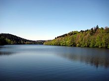
Reservoir Oberilzmühle
| Reservoir Oberilzmühle | |||||||
|---|---|---|---|---|---|---|---|
| The dam with the power plant | |||||||
|
|||||||
|
|
|||||||
| Coordinates | 48 ° 36 '27 " N , 13 ° 26' 45" E | ||||||
| Data on the structure | |||||||
| Construction time: | 1951-1955 | ||||||
| Height above foundation level : | 19 m | ||||||
| Building volume: | 38,000 m³ | ||||||
| Crown length: | 110 m | ||||||
| Power plant output: | 3.4 MW | ||||||
| Data on the reservoir | |||||||
| Water surface | 10 ha | ||||||
| Reservoir length | 5 km | ||||||
| Reservoir width | 200 m | ||||||
| Storage space | 4.5 million m³ | ||||||
The reservoir Oberilzmühle , also Haslach-Speicher , north of Passau in Bavaria in the municipality of Salzweg, dams the river Ilz at Oberilzmühle to the lake.
The city of Passau bought the Oberilzmühle in 1939 to build a new hydroelectric power station. In May 1942, the city had to cede the project to the Arno Fischer Research Center, which wanted to build a so-called underwater power plant under the direction of Arno Fischer . The construction work was carried out by prisoners who were obliged to do forced labor in the Mauthausen subcamp , Passau 1, until the last days of the war.
After the Second World War , the Passau municipal utilities completed the project from 1951 to 1955 as the Oberilzmühle hydropower plant using conventional technology. It has been in operation since 1953. In 1965 and 1966 the dam was increased. This enabled the output to be expanded to a maximum of 500 kilowatts.
The Oberilzmühle reservoir is around five km long. Its width is 40 to 50 m in the upper part and up to 200 m in the lower part. The maximum depth is 14 m. The dam is a gravity dam 19 m high and 110 m long.
With a nominal output of 3.4 MW, the Oberilzmühle power plant on the Ilz produces around 13 million kWh of electricity per year, which roughly corresponds to the electricity needs of 4,000 households.
The reservoir is also used for local recreation . In addition to a public bathing beach on the west, there is a nudist area on the east bank.
Due to the contamination of the Ilz with digested sludge , however, there has been an official bathing ban in the Ilz since 1991. Especially in August, the water quality in the reservoir can deteriorate significantly due to algal blooms .
In 2007 a fish path was built that allows the dam wall to be bypassed on the western side.
See also
Web links
Individual evidence
- ↑ www.mauthausen-memorial.at: The satellite camps of the Mauthausen concentration camp ( Memento from June 28, 2003 in the Internet Archive )
- ↑ Christoph Wagner: Development, rule and fall of the National Socialist movement in Passau from 1920 to 1945 . In: History . tape 9 . Frank & Timme GmbH, Berlin 2007, ISBN 978-3-86596-117-4 , pp. 392 (611 p., Limited preview in Google Book search).


