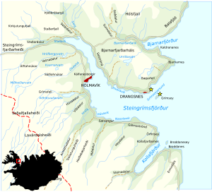
Steingrímsfjörður
| Steingrímsfjörður | ||
|---|---|---|
|
Map of Steingrímsfjörður |
||
| Waters | Húnaflói | |
| Land mass | Iceland | |
| Geographical location | 65 ° 40 ′ N , 21 ° 35 ′ W | |
|
|
||
| width | 7 km | |
| length | 28 km | |
| Tributaries | Staðrá, Seljá | |
The Steingrímsfjörður is a fjord in the eastern part of the Westfjords of Iceland .
As the western arm of the Húnaflói, it protrudes 28 km into the country. Its greatest width is about 7 km. Its name comes from the landlord Steingrímur trölli who settled here. The southern shores of the fjord are more populated. The Innstrandavegur ![]() and the Djúpvegur run here
and the Djúpvegur run here ![]() . And here the fishing village of Hólmavík , which, among other amenities, even has a higher school (Fjölbreytaskóli). Along the north bank, the Strandavegur (road 643) and the Drangsnesvegur (road 645) lead to the small fishing village of Drangsnes on the peninsula of the same name.
. And here the fishing village of Hólmavík , which, among other amenities, even has a higher school (Fjölbreytaskóli). Along the north bank, the Strandavegur (road 643) and the Drangsnesvegur (road 645) lead to the small fishing village of Drangsnes on the peninsula of the same name.
To the east of Hólmavík, also on the north bank, is the small headland Strákatangi. There have been archaeological excavations here that show that the Basques were whaling in the 17th century. At that time one could also communicate verbally .
In the north the area becomes inhospitable but picturesque, especially with the rugged Drangaskarð mountain promontory above the hamlet of Drangar . Þórvaldur Ásvaldsson, the father of Erik the Red , the “discoverer” of Greenland , once settled here .
See also
Individual evidence
- ↑ Baskar á Íslandi - Strákatangi í Steingrímsfirði. (No longer available online.) Archived from the original on November 7, 2017 ; accessed on November 2, 2017 (isl./engl.). Info: The archive link was inserted automatically and has not yet been checked. Please check the original and archive link according to the instructions and then remove this notice.

