Steinklunsen
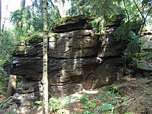
The Steinklunsen (437.2 m) are an elevation in the forest area between Beiersdorfer Wasser and Flössel south of Beiersdorf . On top of it there is a knoll with a rock wall facing north, which is about 40 meters long and up to 4 meters high. The Tannenhof is located on the south-eastern slope .
The name Steinklunsen, formerly known as Beiersdorfer Hain or Hain Steinklausen, indicates that the rocks are split. Name analogies that are independent of the type of rock are also known from other parts of Upper Lusatia. The Nonnenklunsen exist in the Zittau Mountains and the Steinklunsen on the Sonnenhübel in Königsholz near Oderwitz . A corner of the forest carried the name Small Forest in the map of Oberreit compared to the Large Forest which adjoins to the south. Another name as "Stiefelbusch" is said to be related, according to a legend, to a bet that says that the manor owner of Beiersdorf had lost it to the manor owner of Oppach for a pair of boots.
geology
In contrast to the free-standing cliffs and summit cliffs on the Hochstein , the Steinklunsen are connected to the slope on the entire side . This morphological peculiarity can be found in several places in Upper Lusatia and may also have formed under the inland ice cover during the first advance of the Elster Ice Age. The formation of the fissures and banks is particularly evident from the weathering of the sharp-edged two - mica granodiorite under conditions near the ice edge. On the southwest slope of the Steinklunsen the frequent and typical slope steps (an alternation of flattening and steepening) emerge, as it is particularly evident on the northern roof of the Bieleboh . On the south-facing, steeply sloping upper and middle slopes of the elevation, boulders with an edge length of up to 5 meters stand out, which protrude far from the ground.
vegetation
Spruce forest determines the forest like that of the Hahneberg . Arnica ( Arnica montana ) used to be found at the summit of the Steinklunsen .
source
- Between Strohmberg, Czorneboh and Kottmar (= values of our homeland . Volume 24). 1st edition. Akademie Verlag, Berlin 1974.
Individual evidence
- ^ Pfeiffer, AB: History of the parish of Oppach. Neusalza T. 1: 1888 a. T. 2: 1898; Neugersdorf T. 3: 1912.
- ^ Franz, H.-J .: Investigations on the geomorphology of Upper Lusatia. Habil.-Schr. Ped. College. Potsdam 1968.
Coordinates: 51 ° 4 ' N , 14 ° 32' E

