Stem age
| Stem age | ||
|---|---|---|

|
||
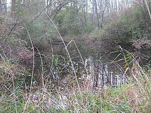
| Looking west (October 2014) | ||
| Geographical location | Bavaria | |
| Tributaries | Groundwater | |
| Islands | no | |
| Places on the shore | Yards | |
| Data | ||
| Coordinates | 48 ° 37 '49.7 " N , 12 ° 26' 53.6" E | |
|
|
||
| Altitude above sea level | 356 m | |
| surface | 0.03 ha | |
| length | 45 m | |
| width | 10 m | |
| scope | 95 m | |
| Maximum depth | 1 m | |
The Stempenalter is a small Isar - backwater in the Teisbach district of the city of Dingolfing in Lower Bavaria .
etymology
Stempen means in Bavarian stake or wooden stake . Age (with feminine gender, the age ) is accordingly the Bavarian name for backwater. The body of water got its name from a stake (or a tree stump) that protruded from the water.
location
The Stempenalter lies between the Isar, which runs 200 meters south, and the Längenmühlbach, which flows past 300 meters further north. The silting still water is only around 40 meters north of the DGF 16 district road and 33 meters north of the cycle path between Schönbühl and the Isar bridge from Teisbach. Because of the dense undergrowth of the alluvial forest , the Stempenalter cannot be seen from the road and is somewhat difficult to access and find for the same reason.
Map and aerial photo
The age of the stem is not recorded on the official topographical map, but on the waterway map of the district fishing club Dingolfing. The Stempenalter is a club water of this sport fishing club , but is classified as uninteresting for fishing . It is difficult or impossible to see in most aerial and satellite images, as it is largely covered by the treetops . It can best be seen on the aerial photo of the BayernAtlas :
Individual evidence
- ^ Topographic map in the Bavaria Atlas
- ↑ Water map of the district fishing club Dingolfing eV: Isar and Weiher ( page no longer available , search in web archives ) Info: The link was automatically marked as defective. Please check the link according to the instructions and then remove this notice.
- ↑ Aerial photo in the Bavaria Atlas
- ↑ BayernAtlas (aerial photo)
