Stieldorferhohn
Stieldorferhohn is a district of the city of Königswinter in the North Rhine-Westphalian Rhein-Sieg district . It belongs to the Stieldorf district and the Oelinghoven district , on December 31, 2019 it had 376 inhabitants.
geography
The village is located on the side of the mountain area of the city of Königswinter in the Pleiser Hügelland facing away from the Rhine and covers altitudes between 180 and 195 m above sea level. NHN . Stieldorferhohn is located on a spur north of the Scharfenberg and sloping down into the Lauterbach valley at its western end. The closest localities include Oelinghoven in the north-west, Bockeroth in the north-east and Sonderbusch and Thomasberg in the south.
history
The settlement history of Stieldorferhohn can be traced back to the time of the Celts . The excavations of prehistoric pile dwellings and finds of rainbow bowls bear witness to this . At the end of the 1990s, a settlement excavation was carried out on the eastern edge of the village, which examined the remains of a pile dwelling settlement from the younger pre-Roman Iron Age. The first written mention of Stieldorferhohn goes back to 1603. The place name is derived from a Höhner Hof located here .
In church terms, Stieldorferhohn belongs to the parish of Stieldorf .
- Population development
| year | Residents |
|---|---|
| 1816 | 144 |
| 1828 | 165 |
| 1843 | 191 |
| 1885 | 236 |
Attractions
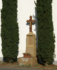
As a monument under monument protection a standing war memorial to the fallen of World War one in the form of the Crossroads from around 1920 (house no. 25), a water pump from the second half of the 19th century (in front of house no. 38) and a Crossroads from 1732 on the corner of Thomasberger Strasse and Stieldorferhohn. Another war memorial for the First and Second World War is located in a square on the corner of Stieldorferhohn and Zum Scharfenberg.
literature
- Georg Armbröster: Chronicle of Stieldorferhohn , Stieldorferhohn, 2005
- Elmar Scheuren, Alfred Schuler: 2000 years ago On the archeology of the Iron Age. Siegburg Rheinlandia Verlag, 1999
Individual evidence
- ↑ without secondary residences ; Population statistics of the city of Königswinter (PDF)
- ^ AA Mützell: New topographical-statistical-geographical dictionary of the Prussian state , Verlag KA Kümmel, Halle 1823, fourth volume, p. 383
- ^ Friedrich von Restorff: Topographical-Statistical Description of the Royal Prussian Rhine Province , Nicolaische Buchhandlung, Berlin and Stettin 1830, p. 303
- ↑ Royal Government of Cologne: overview of the components u. Directory of all localities in the government district of Cologne. Cöln 1845, p. 106. ( Online ub.uni-duesseldorf.de )
- ^ Community encyclopedia for the Kingdom of Prussia , Volume XII Province of Rhineland, Publishing House of the Royal Statistical Bureau (Hrsg.), 1888, pages 118 u. 119
- ↑ Angelika Schyma : City of Königswinter. (= Monument topography Federal Republic of Germany , Monuments in the Rhineland , Volume 23.5.) Rheinland-Verlag, Cologne 1992, ISBN 3-7927-1200-8 , p. 288 f.
Web links
Coordinates: 50 ° 42 ′ 52 ″ N , 7 ° 13 ′ 58 ″ E

