Stob Binnein
| Stob Binnein | ||
|---|---|---|
|
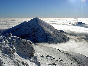
, The summit of Stob Binnein in winter from the northern neighbor summit of Ben More seen |
||
| height | 1165 m ASL | |
| location | Highlands , Scotland | |
| Coordinates | 56 ° 22 '18 " N , 4 ° 32' 8" W | |
|
|
||
The Stob Binnein is a 1,165 meter high mountain in Scotland . Its name means conical peak in Gaelic . It is located in the southern Highlands southeast of the village of Crianlarich above Glen Dochart in the Stirling Council Area and is one of the Munros . It ranks 18th on the list of Scottish highest mountains.

In comparison with the neighboring Ben More , which is only separated by the saddle Bealach Eadar da-Bheinn , which is about 300 meters lower and towering as a mighty grassy pyramid above the Glen Dochart , the Stob Binnein with its slightly gentler grass slopes is considered the more beautiful mountain. Many mountaineers combine the tour with the ascent of Ben More; from the Benmore farm in Glen Dochart, the ascent time is around six hours. Another ascent leads from the south over the 1068 m high pre-summit of the Stob Coire an Lochain, a little southeast of the Stob Binnein, to the Stob Binnein and begins in the small settlement Inverlochlarig west of Balquhidder . Due to its location, the summit of Stob Binnein offers a good view to the west as far as Ben Lui and over the southern highlands to Ben Lawers .
Individual evidence
- ↑ Stob Binnein on www.munromagic.com
- ↑ The Stob Binnein on walkhighlands.co.uk
- ↑ Ben More and Stob Binnein at www.welcometoscotland.com
- ↑ The Ben More on walkhighlands.co.uk
Web links
- The Stob Binnein on walkhighlands.co.uk (English)
- Der Stob Binnein on munromagic.com (English)

