Stonehouse (South Lanarkshire)
| Stonehouse | ||
|---|---|---|
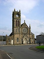
| Church in Stonehouse | ||
| Coordinates | 55 ° 42 ′ N , 3 ° 59 ′ W | |
|
|
||
| Residents | 5506 2011 census | |
| administration | ||
| Post town | LARKHALL | |
| ZIP code section | ML9 | |
| prefix | 01698 | |
| Part of the country | Scotland | |
| Council area | South Lanarkshire | |
| British Parliament | East Kilbride, Strathaven and Lesmahagow , Lanark and Hamilton East | |
| Scottish Parliament | Hamilton, Larkhall and Stonehouse | |
Stonehouse is a village in the Scottish Council Area South Lanarkshire or in the traditional county of Lanarkshire . It is located around twelve kilometers west of Lanark and 22 kilometers southeast of central Glasgow on the right bank of the Avon Waters .
history
The site has been settled for over 2000 years. In the Middle Ages , a church dedicated to Saint Ninian was built in Stonehouse. A sulphurous spring near the banks of the Avon was considered a healing spring for skin diseases. Stonehouse was in the catchment area of two fortifications, Cot Castle and Ringsdale Castle . As in many other localities in the area, textile weavers settled in Stonhouse. After the decline of small weaving mills in the course of industrialization in the 19th century, coal was mined in Stonehouse. The last mine, the Canderigg Colliery , closed in 1954. The neo-Gothic St Ninian's Church , which is used today, was built in 1896.
In July 1973, it was decided to develop Stonehouse as the sixth planned city in the Glasgow area. Although land had already been bought and buildings demolished, the plan was rejected after a change in policy in 1976.
In the second half of the 19th century, around 2,600 people lived in Stonehouse. While 3493 people lived in Stonehouse in 1951, the number rose to 5506 in 2011.
traffic
The A71 ( Edinburgh - Irvine ) runs along Stonehouse's north flank. Furthermore, the A723 ( Strathaven - Holytown ) and the A726 ( Erskine - Strathaven ) can be reached within a few kilometers. There is a connection to the M74 motorway in the east .
On the west edge of the A71 crossed on the 1823 completed Canderside Bridge the Cander Water , which flows north-east of Stonehouse in the Avon Water. Around 50 m downstream, a new crossing was completed in 1965, on which the A71 now crosses the river. The Canderside Bridge became obsolete and is no longer of any infrastructural importance.
A crossing station of the Caledonian Railway was located in Stonehouse . With the decline of coal production, the line was abandoned in the 1960s. The Stonehouse Viaduct , built in 1904 , on which the railway line crossed the Avon Water, was dismantled in 1984 with the exception of the pillars.
Individual evidence
- ↑ a b c d Entry in the Gazetteer for Scotland
- ^ Stonhouse in: FH Groome (ed.): Ordnance Gazetteer of Scotland: A Survey of Scottish Topography, Statistical, Biographical and Historical , Grange Publishing Works, Edinburgh, 1882–1885.
- ↑ Listed Building - Entry . In: Historic Scotland .
- ^ Information in the Gazetteer for Scotland
- ↑ 2011 census data
- ↑ Listed Building - Entry . In: Historic Scotland .

