Street (moon crater)
| Street | ||
|---|---|---|

|
||
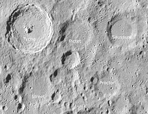
| Street (bottom left) and surroundings ( LROC -WAC) | ||
|
|
||
| position | 46.6 ° S , 10.84 ° W | |
| diameter | 59 km | |
| depth | 2670 m | |
| Card sheet | 112 (PDF) | |
| Named after | Thomas Street (1621-1689) | |
| Named since | 1935 | |
| Unless otherwise stated, the information comes from the entry in the IAU / USGS database | ||
Street is an impact crater south of the lunar front , south of Mare Nubium , south of Tycho crater, and west of Proctor . The crater is badly eroded.
| Letter | position | diameter | link |
|---|---|---|---|
| A. | 46.98 ° S , 9.19 ° W | 17 km | [1] |
| B. | 47.05 ° S , 12.25 ° W | 13 km | [2] |
| C. | 48.46 ° S , 15.55 ° W | 12 km | [3] |
| D. | 48.9 ° S , 12.81 ° W | 9 km | [4] |
| E. | 47.47 ° S , 11.99 ° W | 12 km | [5] |
| F. | 48.25 ° S , 16.82 ° W | 7 km | [6] |
| G | 46.7 ° S , 15.23 ° W | 10 km | [7] |
| H | 48.41 ° S , 12.38 ° W | 28 km | [8th] |
| J | 48.76 ° S , 13.81 ° W | 6 km | [9] |
| K | 47.58 ° S , 13.28 ° W | 9 km | [10] |
| L. | 50.73 ° S , 13.73 ° W | 6 km | [11] |
| M. | 47.82 ° S , 14.62 ° W | 45 km | [12] |
| N | 48.29 ° S , 10.45 ° W | 4 km | [13] |
| P | 45.65 ° S , 12.07 ° W | 6 km | [14] |
| R. | 49.16 ° S , 14.73 ° W | 5 km | [15] |
| S. | 48.99 ° S , 14.95 ° W | 4 km | [16] |
| T | 49.29 ° S , 15.3 ° W | 9 km | [17] |
The crater was officially named by the IAU in 1935 after the British astronomer Thomas Street .
Web links
Individual evidence
- ^ John E. Westfall: Atlas of the Lunar Terminator. Cambridge University Press, Cambridge et al. 2000, ISBN 0-521-59002-7 .
