Suðureyri
| Suðureyri | ||
|---|---|---|
|
|
||
| Coordinates | 66 ° 8 ′ N , 23 ° 32 ′ W | |
| Basic data | ||
| Country | Iceland | |
| Vestfirdir | ||
| ISO 3166-2 | IS-4 | |
| local community | Ísafjarðarbær | |
| Residents | 264 (January 1, 2019) | |
|
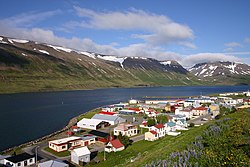
Suðureyri in June 2008
|
||
Suðureyri is a small fishing village belonging to the municipality of Ísafjarðarbær in the Vestfirðir region in the far northwest of Iceland . On January 1, 2019, the place had 264 inhabitants.
geography
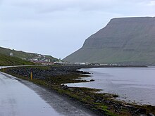
Suðureyri is located on the south coast of Súgandafjörður . There is a hot spring nearby, the water of which is used for heating. On the north coast of the fjord, north of the village, the mountain Góltur rises up. To the south is the mountain Ufsir .
history
The first permanent houses in Suðureyri date back to around 1900. In the period that followed, fishing was particularly important in economic terms. In 1996, the previously independent municipality Suðureyri was combined with five other municipalities to Ísafjarðarbær .
traffic
The distance to Ísafjörður is 23 kilometers by road and to Reykjavík 500 kilometers. Suðureyri is connected to the neighboring villages by an approximately 10 km long network of tunnels built in 1996.
Web links
- Some tourist information (Icelandic, English)
Individual evidence
- ↑ a b sudureyri.is. Retrieved on September 6, 2012. ( Memento of the original from June 5, 2015 in the Internet Archive ) Info: The archive link was inserted automatically and has not yet been checked. Please check the original and archive link according to the instructions and then remove this notice.


