Sungai Merbok
| Merbok | ||
|
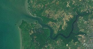
Satellite image of the Merbok |
||
| Data | ||
| location | Malaysia; in the state of Kedah | |
| River system | Merbok | |
| source | Gunung Jerai and Sungkap Forest | |
| muzzle | in the Strait of Malacca Coordinates: 5 ° 41 ′ 0 ″ N , 100 ° 21 ′ 0 ″ E 5 ° 41 ′ 0 ″ N , 100 ° 21 ′ 0 ″ E |
|
| Mouth height |
0 m
|
|
| length | 45 km | |
| Catchment area | 439 km² | |
Sungai Merbok is a small river in the state of Kedah , Malaysia .
geography
It has a length of around 45 km and a catchment area of around 439 km². Its sources are at Gunung Jerai and in the Sungkap Forest. However, it only got its name after the confluence of its two source rivers, the Sungai Bongkok and Sungai Lalang. It flows into the Strait of Malacca about 24 km north of Penang Island , forming a delta about 2.5 km wide. Other tributaries are Sungai Petani and Sungai Bujang.
Individual evidence
- ↑ a b Review of the National Water Resources Study (2000-2050) and Formulation of National Water Resources Policy - Vol 8 Kedah. (PDF; MB) (No longer available online.) Formerly in the original ; accessed on March 7, 2014 . ( Page no longer available , search in web archives ) Info: The link was automatically marked as defective. Please check the link according to the instructions and then remove this notice.
