Swid
|
swid Свидь |
||
|
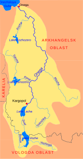
Swid in the catchment area of the Onega |
||
| Data | ||
| Water code | RU : 03010000112103000000154 | |
| location | Arkhangelsk Oblast ( Russia ) | |
| River system | Onega | |
| Drain over | Onega → White Sea | |
| origin |
Woschesee 60 ° 46 ′ 12 " N , 38 ° 55 ′ 42" E |
|
| Source height | 120 m | |
| muzzle |
Lacha Coordinates: 61 ° 11 ′ 25 " N , 38 ° 44 ′ 33" E 61 ° 11 ′ 25 " N , 38 ° 44 ′ 33" E |
|
| Mouth height | 117 m | |
| Height difference | 3 m | |
| Bottom slope | 0.05 ‰ | |
| length | 64 km | |
| Catchment area | 6850 km² | |
| Discharge at the Gorky A Eo gauge : 6450 km² Location: 44 km above the mouth |
MNQ 1927/1988 MQ 1927/1988 Mq 1927/1988 MHQ 1927/1988 |
27 m³ / s 59 m³ / s 9.1 l / (s km²) 119 m³ / s |
The Swid ( Russian Свидь ) is a river in the Kargopolski rajon in the southwest of the Arkhangelsk Oblast in northwestern Russia . The river connects the Woschesee with the northern Latschasee and lies in the catchment area of the Onega . The length of the Swid is 64 km, its catchment area covers 6850 km².
The Swid has its origin in the Wosche Lake on the border with the Vologda Oblast . From there it flows in a northerly direction through sparsely populated area. Its river width varies between 40 and 120 m on its upper reaches. Wetlands and forests stretch along its banks.
At the middle reaches its banks become stony. There are smaller rapids. The river width is reduced to 10 to 15 m. The flow speed increases in this section of the river.
The flow velocity decreases again at the underflow. It finally flows into the southern end of the Laces lake, which is drained from the Onega to the White Sea .
Individual evidence
- ↑ a b Swid in the State Water Register of the Russian Federation (Russian)
- ↑ Swid at the Gorky gauge - hydrographic data at R-ArcticNET
