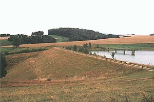
Königsfeld dam
| Königsfeld dam | |||||||||
|---|---|---|---|---|---|---|---|---|---|
| Königsfeld dam and reservoir | |||||||||
|
|||||||||
|
|
|||||||||
| Coordinates | 51 ° 4 ′ 34 " N , 12 ° 46 ′ 43" E | ||||||||
| Data on the structure | |||||||||
| Construction time: | 1978-1984 | ||||||||
| Height above valley floor: | 16 m | ||||||||
| Height above foundation level : | 20 m | ||||||||
| Height of the structure crown: | 174.9 m | ||||||||
| Crown length: | 150 m | ||||||||
| Crown width: | 3.5 m | ||||||||
| Data on the reservoir | |||||||||
| Water surface | 11 ha | ||||||||
| Reservoir length | 1.2 km | ||||||||
| Reservoir width | 80 m | ||||||||
| Storage space | 0.54 million m³ | ||||||||
| Catchment area | 4.16 km² | ||||||||
The Königsfeld dam (also called Weiditz reservoir) is a dam in Saxony ( Germany ). It is located northwest of Rochlitz in the municipality of Königsfeld in the district of Central Saxony and was built from 1978 to 1984. The barrier structure is a dam . The dammed body of water is the Weißbach.
The lake is up to 14.60 m deep; it takes 80 days to drain.
The purpose of the dam, according to the list of dams (see below), is commercial fishing and nature conservation.
Fishing is possible.
See also
Web links
Commons : Königsfeld Reservoir - Collection of images, videos and audio files

