Tang Weighed
| Tang Weighed | |
|---|---|
 |
|
| Basic data | |
| Country | Bhutan |
| District | Thump |
| surface | 511 km² |
| Residents | 1816 (2005) |
| density | 3.6 inhabitants per km² |
| ISO 3166-2 | BT-33 |
Coordinates: 27 ° 35 ' N , 90 ° 53' E
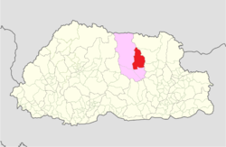
Tang ( Dzongkha : སྟང་ ) is one of four Gewogs (blocks) of the Dzongkhag Bumthang in central Bhutan . Tang Gewog is in turn divided into five Chiwogs (constituencies). The Gewog is located in the eastern part of Bumthang and extends over altitudes between 2800 and 5000 m . According to the 2005 census, 1816 people in 32 (according to the electoral commission's census 26) villages or hamlets in around 300 households live in this area of 511 km².
The schools in the Gewog include two elementary schools and one secondary school, the Mesithang Lower Secondary School . For medical care there is a basic care center ( BHU, Basic Health Unit ) and eleven community health workers ( VHW, Village Health Worker ).
The people of Tang Gewog make a living mainly from agriculture and cattle breeding. Wheat, barley, buckwheat and, as cash crops, potatoes and apples are grown. In the village of Tandingang there is a dairy that was originally a sheep rearing center operated by the Ministry of Agriculture. In 1997, the fourth King Jigme Singye Wangchuck transferred the farm to the people of Tang Gewog.
| Chiwog | Villages or hamlets |
|---|---|
| Tadingang རྟ་ མཁྲི་ སྒང་ |
Tanding |
| Khangrab ཁང་ རབས་ |
Benzabi |
| Chhutoe | |
| Gambling | |
| Khangrab | |
| Khoyar | |
| Namkha | |
| Shobugoenpa | |
| Tashiling (tang) | |
| Ugyenchholing | |
| Kidzom Nyimalung སྐྱིད་ འཛོམས་ _ ཉི་མ་ ལུང་ |
Chojam |
| Gangju | |
| Kidzom | |
| Nangnang | |
| Nimalung | |
| Tralang | |
| Sameth | |
| In addition མདའ་ ཟུར་ |
Besides |
| Jamshong | |
| Jog | |
| Missertang | |
| Pangshing | |
| Rimochen | |
| Bezur Kuenzargdrag སྦས་ ཟུར་ _ ཀུན་ བཟང་ བྲག་ |
Bezur |
| Kuenzangdag | |
| Phom Drong |
Web links
- Tang. Dzongkhag Administration Bumthang, accessed on 18 February 2017 (English).
- Chiwogs in Bumthang. (PDF, 922 kB) Election Commission, Government of Bhutan , February 19, 2016, accessed on February 15, 2017 .
- Data from the 2005 Census. www.statoids.com, accessed February 17, 2017 (English).
