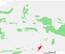
Tanimbar Islands (Administrative Region)
| Kabupaten Kepulauan Tanimbart Tanimbar Islands Governorate
|
||
|---|---|---|
 |
||
| Symbols | ||
|
||
| Basic data | ||
| Country | Indonesia | |
| province | Maluku | |
| Seat | Saumlaki | |
| Residents | 103,088 (2009) | |
| ISO 3166-2 | ID-MA | |
| Image of Yamdena from colonial times | ||
Coordinates: 7 ° 58 ′ S , 131 ° 18 ′ E
The administrative district of Tanimbar Islands ( Indonesian Kabupaten Kepulauan Tanimbart ), formerly Western Southeast Moluccas ( Indonesian Maluku Tenggara Barat ), is an administrative region ( Kabupaten ) in the Indonesian province of Maluku .
103,088 people (2009) live on the western Southeast Moluccas.
geography
The Tanimbar Islands Governorate consists of the Tanimbar Islands . The capital is Saumlaki on Yamdena .
The administrative district is divided into the districts ( Kecamatan ) Tanimbar Selatan (South Tanimbar), Wer Tamirian , Wer Maktian , Selaru , Tanimbar Utara (North Tanimbar), Yaru , Wuar Labobar , Nirunmas and Kormomolin .
Web links
Commons : Tanimbar Islands Regency - Collection of images, videos and audio files
Individual evidence
- ↑ a b Profile of Maluku Tenggara Barat ( memento of the original from September 13, 2014 in the Internet Archive ) Info: The archive link was inserted automatically and has not yet been checked. Please check the original and archive link according to the instructions and then remove this notice.
- ↑ Map of the infrastructure of the Maluku province (Indonesian).
- ↑ Penduduk Indonesia menurut desa 2010 ( Memento from March 27, 2014 in the Internet Archive ) (Indonesian; PDF; 6.0 MB), accessed on January 26, 2013
- ^ Map of the administrative division of the Western Southeast Moluccas


