Tchigaï plateau
| Tchigaï plateau
Plateau de Tchigaï
|
||
|---|---|---|
| location | Agadez region , Niger | |
|
|
||
| Coordinates | 21 ° 30 ′ N , 14 ° 54 ′ E | |
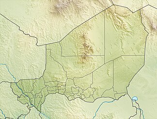
The Tchigaï Plateau ( French : Plateau de Tchigaï ) is a plateau in Niger .
The Tchigaï Plateau is located in the Sahara on the Niger- Chad border . With the Djado plateau and the Manguéni plateau , it is one of the three high plateaus that shape the landscape in the north-east of the country. It reaches a height of 880 m .
Geographically, the Tchigaï Plateau belongs to the Paleozoic . The desert plain has the character of a lunar landscape . A chain of wells, some of which are very salty, makes it possible to cross it as a connection between the Kaouar Valley and the Tibesti Mountains .
literature
- Detlef Busche : The sandstone karst relief of the Tchigai, northeast Niger . In: Rüdiger Glaser (Ed.): Geoscientific contributions to research, teaching and practice: Festschrift for Horst Hagedorn . Institute for Geography at the University of Würzburg, Würzburg 1993, p. 63-84 .
- Peter Felix-Henningsen: Early Holocene wet season soils on old dunes of the Ténéré and the Tchigai mountainous country, East Niger . In: Horst Hagedorn (Hrsg.): Geoscientific investigations in Africa . No. II . Institute for Geography at the University of Würzburg, Würzburg 1992, p. 97-129 .
Individual evidence
- ↑ Niger. (PDF) map. Ministère des Affaires étrangères et du Développement international, direction des Archives (pôle géographique), December 2014, accessed on June 15, 2017 (French).
- ↑ Thomas Krings : Sahel countries . WBG, Darmstadt 2006, ISBN 3-534-11860-X , p. 16 .
- ↑ Marc Carlier: Méharistes du Niger. Contribution to l'histoire des unités montées à chameau du territoire nigérien: 1900 to 1962 . L'Harmattan, Paris 2000, ISBN 2-7384-9886-8 , pp. 19 .
