Tejstymy (lake)
| Tejstymy | ||
|---|---|---|
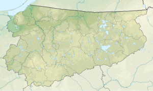
| Geographical location | Powiat Olsztyński , Masurian Lake District , Warmian-Masurian Voivodeship , Poland | |
| Tributaries | Biesówka | |
| Drain | Biesówka → Daddaisee ( Dadaj ) | |
| Islands | 1 | |
| Places on the shore | Biesowo and Biesówko ( Groß and Klein Bössau, Biskupiec municipality ) | |
| Location close to the shore | Tejstymy ( Teistimmen, Kolno Municipality ) | |
| Data | ||
| Coordinates | 53 ° 57 '0 " N , 20 ° 53' 0" E | |
|
|
||
| Altitude above sea level | 117 m npm | |
| surface | 1.99 km² | |
| Maximum depth | 23.4 m | |
The Tejstymy ( German Bössauer See ) is a lake in Poland with an area of 199 ha. It has a rectangular shape with pronounced bays in the southern and northern parts. In the middle of the lake is a wooded island with an area of 12 hectares. The lake is relatively shallow with a maximum depth of 23.4 m.
history
On the south and east banks of the lake, at the beginning of the Battle of Tannenberg on August 26, 1914, there was a battle on Lake Bössau , which resulted in a German victory and the disorderly retreat of VI. Corps of the 2nd Russian Army ended. As a result, the German troops were able to close the ring to encircle the 2nd Army in the east in the following days. Alexander Solzhenitsyn took up the defeat of the Russian troops in the battle on Lake Bössauer in his novel August Fourteen .
literature
- Rozalia Przybytek: Hydronymia Europaea. Place names of Baltic origin in the southern part of East Prussia . Stuttgart 1993.
Footnotes
- ↑ Hellmuth Neumann: The history of the Reserve Infantry Regiment No. 59 in the World War (1914-1918) . Gerhard Stalling, Oldenburg and Berlin 1927, pp. 15-17.
- ↑ Alexander Solzhenitsyn: August fourteen . Translated by Swetlana Geier. Luchterhand (= Luchterhand Collection, Vol. 183), Darmstadt and Neuwied 1974, ISBN 3-472-61183-9 , p. 186.
