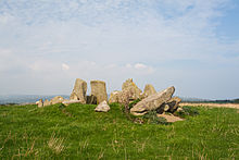
Temple of Deen
The Temple of Deen (also called Court Tomb of Laraghirril) is a Neolithic chamber tomb classified as Court Tomb , located in the townland of Laraghirril, northeast of the Inishowen peninsula , about two kilometers south of Culdaff southwest of the Bocan stone circle in County Donegal in Ireland . Court Tombs are among the megalithic chamber tombs ( English chambered tombs ) of the British Isles . With around 400 specimens, they are found almost exclusively in Ulster in the north of Ireland or in Northern Ireland .
Surname
The popular name Temple of Deen refers to Deen, the eastern part of the townland of Laraghirril, and is based on the earlier assumption that these were druid temples . In the map edition of the Ordnance Survey from 1900, the monument is referred to as Druid's Altar . Other locally used names include "Diarmuid and Gráinne's bed", based on the legend of the same name from the Finn cycle .
Geographical location and context
The facility is located on the flat plateau of the Black Hill ridge , which slopes north, west and south to the valleys of the Culdaff River and its tributary, the Thraboy River. From the point of view of the facility, wide views open up, in the north to the open sea of Culdaff Bay and in the west to the Raghtin More, the mountain range in the north-west of Inishowen. Only in a north-easterly direction is the view limited by Mass Hill , about a kilometer away , on which the Bocan stone circle is located.
The monument belongs to the region described by Sean Beattie as a Bronze Age triangle, to which, in addition to Laraghirril, the stone circle of Bocan in the northwest and the early field system in the townlands of Kindroghed and Knockergrana further east. Even if Beattie attributed the complex to the Bronze Age, Michael Herity and Eamon Cody generally assigned the graves classified as court tombs to the Neolithic, since excavations of the corresponding graves have always been associated with this era. So far, however, no excavations have taken place in Laraghirril (status 2014).
construction
The facility consists of an 8.5 m long gallery, which is separated by a passage with two threshold stones, which is enclosed by two high stones that tower above the facility. An inner courtyard can no longer be seen and the dimensions of the earlier burial mound can still be guessed, as the complex is located on an area around 0.6 m elevated, 20 m long and 6 m wide. The orientation of the plant is from southeast to northwest. The entrance is assumed to be on the southeast side of the eastern chamber, as there are double stones on both sides that allow a passage. According to a description of the facility from 1867, there was a stone circle around the facility with a diameter of 64 m. This can no longer be proven on site.
The eastern chamber is 3 m long and 2.4 m wide. Three orthostats with heights between 1.1 and 1.55 m form the north side, while only two lower orthostats can be found on the south side. The western chamber extends over 3.5 m in length with a maximum width of 2.5 m in the middle. The shape of the chamber, which narrows towards the west, is seen as evidence that it is the end chamber. The chamber is open to the northwest. The resulting hypothesis that this could have been a very small courtyard is now considered unlikely.
See also
literature
- Brian Lacy: Archaeological Survey of County Donegal . Donegal County Council, Lifford 1983, ISBN 0-9508407-0-X , pp. 24 .
- Eamon Cody: County Donegal (= Survey of the Megalithic Tombs of Ireland . Volume VI). Stationary Office, Dublin 2002, ISBN 0-7557-1248-X , pp. 106-107 .
Web links
- Video (last accessed December 11, 2012)
- Description ( last accessed on December 11, 2012)
- Image (last accessed on December 11, 2012)
Remarks
- ↑ Sean Beattie: Ancient Monuments of Inishowen, North Donegal . Lighthouse Publications, Carndonagh 1994, ISBN 0-9520481-1-6 , pp. 9 .
- ↑ Sean Beattie: The Temple of Deen Culdaff. Retrieved March 22, 2015 .
- ↑ Maghtochair: Inishowen: Its History, Traditions & Antiquities . Londonderry 1867, p. 14 (English, archive.org ): “In the locality last named, in the Parish of Culdaff, there seems to have been an assemblage of Druidical temples, for at Larahirl are a number of stones, […]”
- ↑ a b Lacy, p. 24.
- ^ Robert S. Young: Archaeological Rambles in the Inisowen Mountains . In: Ulster Journal of Archeology . tape III . Belfast 1897, p. 199 (English, archive.org ): “It is called by the country people 'the bed of Diarmid and Greine,' […]”
- ↑ a b c d e Cody, p. 106.
- ↑ Lacy, pp. 52-54
- ↑ Sean Beattie: Ancient Monuments of Inishowen, North Donegal . Lighthouse Publications, Carndonagh 1994, ISBN 0-9520481-1-6 , pp. 9-10 .
- ↑ Michael Herity: The Finds from Irish Court Tombs . In: Proceedings of the Royal Irish Academy. Section C: Archeology, Celtic Studies, History, Linguistics, Literature . tape 87 C, 1987, pp. 103-281 , JSTOR : 25506150 .
- ↑ Cody, p. 261.
- ↑ See the Irish excavation database at excavations.ie
- ↑ Plans in Figure 11 (b) in Lacy, p. 23, and Figure 41 in the Appendix by Cody.
- ↑ Maghtochair: Inishowen: Its History, Traditions & Antiquities . Londonderry 1867, p. 14 (English, archive.org ).
- ^ Cody, p. 107.
Coordinates: 55 ° 16 ′ 0.5 ″ N , 7 ° 9 ′ 25 ″ W.


