Tetela del Volcán
| Tetela del Volcán | ||
|---|---|---|
|
Coordinates: 18 ° 54 ′ N , 98 ° 44 ′ W Tetela del Volcán on the map of Morelos
|
||
| Basic data | ||
| Country | Mexico | |
| State | Morelos | |
| Municipio | Tetela del Volcán | |
| Residents | 10,199 (2010) | |
| City insignia | ||
| Detailed data | ||
| height | 2231 m | |
| prefix | 731 | |
| Website | ||
| Tetela main street with Popocatépetl volcano in the background | ||
Tetela del Volcán ( Nahuatl Tetela , 'rocky place') is a town on the slopes of the Popocatépetl volcano in the Mexican state of Morelos with a population of over 10,000. Tetela del Volcán is the seat of the municipality of the same name, Tetela del Volcán .
history
In 1503 Tetela del Volcán and the nearby Hueyapan were subjected to the Aztec Empire by Moctezuma II . The first Spaniards reached Tetela in 1519. After the fall of Tenochtitlán , Hernán Cortés also reached Tetela, where he initially encountered fierce resistance from the indigenous population.
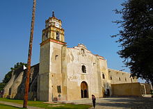
Tetela is best known for the San Juan Bautista Monastery , a recognized UNESCO World Heritage Site , which is one of the mission stations at the foot of the Popocatépetl . The monastery was built by the Dominicans in the first half of the 16th century .
credentials
- ↑ Earliest 16th-Century Monasteries on the Slopes of Popocatepetl . World Heritage Organization. Retrieved November 10, 2014.


