
Teufenbachweiher
| Teufenbachweiher | |||||||||
|---|---|---|---|---|---|---|---|---|---|
 |
|||||||||
|
|||||||||
|
|||||||||
| Coordinates | 690 950 / 226225 | ||||||||
| Data on the structure | |||||||||
| Lock type: | Earthfill dam | ||||||||
| Construction time: | 1895 | ||||||||
| Height of the barrier structure : | 16 m | ||||||||
| Building volume: | 40,000 m³ | ||||||||
| Crown length: | 120 m | ||||||||
| Operator: | Electricity works of the Canton of Zurich | ||||||||
| Data on the reservoir | |||||||||
| Water surface | 4.2 ha | ||||||||
| Reservoir length | 300 m | ||||||||
| Storage space | 230,000 m³ | ||||||||
| Catchment area | 1.25 km² | ||||||||
| Design flood : | 10 m³ / s | ||||||||

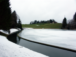
The Teufenbachweiher is a reservoir in the canton of Zurich in the municipality of Wädenswil . It is located on the north side of a forest halfway between Hütten and Menzingen .
The Teufenbachweiher is operated together with the Waldhalde power plant by the electricity works of the Canton of Zurich (EKZ). To operate the system, water from the Sihl is led from Hütten through a 2.2 km long tunnel into the pond. The power plant uses the 72 meter difference in altitude to the turbine house in the forest heap. The relaxed water is then fed back into the Sihl.
Web links
Commons : Teufenbachweiher - collection of images, videos and audio files
Individual evidence
- ↑ Teufenbachweiher dam (Hütten, 1895). In: structurae.de. Retrieved March 12, 2014 .
- ↑ Geonames: Teufenbachweiher
- ↑ The Waldhalde power plant will be made fit for the period up to 2047. In: tagesanzeiger.ch. Retrieved July 12, 2019 .