Theatrum Belli Rhenani
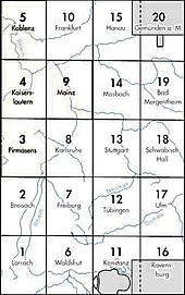
The Theatrum Belli Rhenani (German: Der Kriegsschauplatz am Rhein ) is a set of maps by the cartographer Cyriak Blödner , which was originally created between 1713 and 1715. The card consists of 20 individual sheets and measures a total of 290 × 170 cm. It is oriented to the west.
A second edition of this map was created between 1717 and 1725 and is in the Vienna War Archives under the same signature .
cover
The map shows true to detail the southern German landscape between
- Lauterbach (north)
- Ochsenfurt (east)
- Baden AG (south)
- Andernach (west)
See also
literature
- Wilhelm Bonacker: Life and work of the Austrian military cartographer Cyriak Blödner (1672–1733) . In: Communications from the Austrian State Archives. Volume 10, 1957, pp. 92-135.
- Roland Häberlein (ed.): Explanations on the Theatrum Belli Rhenani / The theater of war on the Rhine 1713/1714 ( reproductions of old maps ). State Surveying Office Baden-Württemberg, Stuttgart 1994.

