Ticknall Tramway
| Ticknall Tramway | |||||||||||||||||||||||||||||||||||||||||||||||||
|---|---|---|---|---|---|---|---|---|---|---|---|---|---|---|---|---|---|---|---|---|---|---|---|---|---|---|---|---|---|---|---|---|---|---|---|---|---|---|---|---|---|---|---|---|---|---|---|---|---|
|
Drive to maintain the right-of-way
| |||||||||||||||||||||||||||||||||||||||||||||||||
|
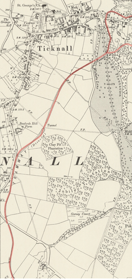
Route (excerpt), 1901
| |||||||||||||||||||||||||||||||||||||||||||||||||
| Route length: | 20.651 km | ||||||||||||||||||||||||||||||||||||||||||||||||
| Gauge : | 1270 mm | ||||||||||||||||||||||||||||||||||||||||||||||||
|
|||||||||||||||||||||||||||||||||||||||||||||||||
The Ticknall Tramway was a 20.6 km long, from 1802 to 1913 operated horse-drawn tram with a gauge of 4 feet 2 inches (1270 mm) in Ticknall , Derbyshire , England .
location
The horse-drawn tram connected the brickworks, limestone quarries and lime storage areas of Ticknall with the Ashby Canal . There were also branches to the quarries on Cloud Hill and the Smoile and Lount pits.
history
The construction of the horse-drawn tram was approved by an Act of Parliament of May 25, 1794. The Ashby Canal Company decided on August 21, 1798 to contact Benjamin Outram of the Butterley Company in Derbyshire regarding the usefulness of railroads. The company approved his proposals in December 1798 and issued instructions for the route. In December 1799, the company decided that it could not afford a double-track line along the entire length, and therefore had the line from the Old Parks Tunnel to Ticknall built as a single track, while that from Willesley to Old Parks was double-tracked. Due to the tight liquidity, Outram threatened in February 1801 with the suspension of the work if he was not paid. The company, for its part, complained about the standard of Outram's way of working and hired Joseph Wilkes of Measham and other inspectors to survey the route in 1802 and 1803. Their reports show the length of the route sections that opened between July and October 1802 as follows:
| Route section | British units of measure | kilometre |
|---|---|---|
| From Willesley to Old Parks | 3 miles + 72 chains + 7 yards | 6.283 km |
| From Old Parks to Cloud Hill | 4 miles + 2 chains + 16 yards | 6.492 km |
| From Old Parks to Ticknall | 4 miles + 1 chains + 2 yards | 6.459 km |
| Branch from Ticknall to Burdett's Works | 29 chains + 13 yards | 0.595 km |
| Branch line to Marget's Close | 17 chains + 19 yards | 0.359 km |
| Total length (without passing points and sidings) | 12 miles + 43 chains + 13 yards | 20.189 km |
| Passing points and sidings | 22 chains + 21 yards | 0.462 km |
| overall length | 12 miles + 66 chains + 12 yards | 20.651 km |
The horse-drawn tram went into operation informally between July and October 1802. It was last used in 1913 and officially decommissioned in 1915. The horse-drawn tram is considered “far ahead of its time” and “a milestone in traffic engineering” as well as a role model for railways that were built 30 years later.
Tracks
The L-shaped cast iron rails, 0.91 m (3 feet ) in length and an average weight of 17.3 kg, were mounted on stone sleeper blocks of at least 68.2 kg (150 lbs). Then wagons with rimless wheels were pulled by horses. The rails were cast by Benjamin Outram in the Butterley Ironworks, which were probably at full capacity for 15 months.
The running surface of the rails was 4 inches (100 mm) wide and the upright land was 2 inches (50 mm) high at the ends and 3–3½ inches (75-90 mm) high in the middle. They were called the “Outram Way”. The track gauge was 4 ft 2 in (1207 mm), which is 8 in. (203 mm) more than Outram's previous horse-drawn trams, as he believed the extra width would mean greater capacity for general freight. The horse-drawn tram was double-track south of Old Parks.
Buildings
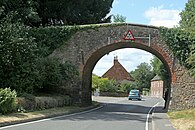
Cuts and embankments can still be seen in the park and adjacent farmland, as well as a bridge ( The Arch ), which is still used by agricultural vehicles today. The bridge, which is now a listed building and has a vault reminiscent of canal bridges, is one of the oldest railway bridges in the world and is therefore listed as a Grade II monument .
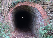
Two in open construction built tunnels are preserved in Calke Park, one of which is 122 m long. In it, the horse-drawn tram crossed the access avenue to Calke Abbey, the Harpur family estate. Stone sleeper blocks can still be seen at various points along the route.
business
Benjamin Outram's planning was based on the assumption that two horses would be needed on the plain to carry a train, with an additional horse on the climb from Ticknall to the summit on Pistern Hill, which a boy would bring back four times a day to help other trains travel uphill. So 4 men, 1 boy and 9 horses were needed to transport 40 tons of stones a day from Ticknall to the Ashby Canal and in the opposite direction about 12 tons of coal, coal dust and other goods.
literature
- Gerry Calderbank: Canal, Coal & Tramway: An Introduction to the Industrial Heritage of Mamble. LC Promotions, 2000
- Geoffrey Holt: The Ticknall Tramway. Ticknall Preservation and Historical Society, 2002
- I. Stabb and T. Downing: The Redlake Tramway and the China Clay Industry. T. Downing, 1977
- John Stanley Webb: Black Country Tramways: Company-worked Tramways and Light Railways of the West Midlands Industrial Area: 1913-39. JS Webb, 1976, ISBN 0950376418 .
Web links
Individual evidence
- ↑ Bryan Smith: Ticknall Limeyards, Nov. 7, 2014.
- ↑ a b Calke Park Tunnel.
- ^ A b C. R. Clinker and Charles Hadfield: The Ashby-de-la-Zouch Canal and its Railways. Leicestershire Archæological and Historical Society. Pages 65 and 67.
- ↑ a b c d e f Ticknall Tramway. on www.transporttrust.com
- ^ Donald J. Grant: Directory of the Railway Companies of Great Britain. Page 562.
- ^ AKB Evans and JV Gough: The Impact of the Railway on Society in Britain: Essays in Honor of Jack Simmons. Routledge, 2017.
- ^ A b c d Marilyn Palmer and Peter Neaverson: The Ticknall lime Industry and its Transport System.
- ↑ RB Schofield: Benjamin Outram 1764-1805 - An Engineering Biography. Merton Priory Press, 2000, ISBN 1898937427 .
- ↑ a b The "Outram Way." In: Locomotive Firemen's Magazine (1901).
- ^ Clement Edwin Stretton: The history of the Midland Railway. Methuen & Co., 1901.
- ^ WT Jackman: The Development of Transportation in Modern England. Cambridge University Press, 2014. page 465.
- ↑ Views of the Outram-way laid by Benjamin Outram (1764-1805) at Ticknall in 1799… Institution of Mechanical Engineers Archive, IMS 195 / 13-14.
Coordinates: 52 ° 48 ′ 36.5 ″ N , 1 ° 28 ′ 22.9 ″ W.


