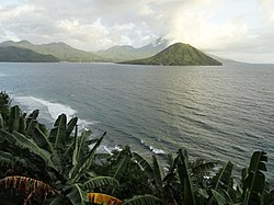
Tidore Islands
| Kota Tidore Kepulauan Tidore Islands
|
|
|---|---|
 The Tidore Islands and their neighbors |
|
| Basic data | |
| Country | Indonesia |
| Capital | Soasio |
| surface | 1,550.4 km² |
| Residents | 48,678 (2015) |
| density | 31 inhabitants per km² |
| ISO 3166-2 | ID-MU |
| The island Tidore and its upstream Maitara from Ternate seen from | |
Coordinates: 0 ° 41 ' N , 127 ° 24' E
The Indonesian city ( Kota ) of the Tidore Islands ( Indonesian Tidore Kepulauan ) is administratively directly subordinate to the province of the Northern Moluccas .
geography
The administrative unit of the city consists of the island of Tidore and part of the west coast of the island of Halmahera . The seat of government is Soasio .
The island of Tidore is divided into four districts ( Kecamatan ). In the northwest lies the north tidore ( Tidore Utara ) with the offshore island of Maitara . The northeast is formed by the East Tidore ( Tidore Timur ). In the southeast is the Tidore district with the seat of government for the Soasio administrative district. The island of Mare also belongs to the south tidore ( Tidore Selatan ) in the south .
The area on Halmahera belonging to the city of Tidore is divided into the districts of Nordoba ( Oba Utara ), Zentraloba ( Oba Tengah ), Oba and Südoba ( Oba Selatan ). The city of Sofifi , which has been the capital of the province since August 4, 2010, is also located in Nordoba .
Individual evidence
- ↑ a b c Map of the city of Tidore , accessed July 23, 2013
- ^ Administrative map of Tidore Island , accessed July 23, 2013
- ↑ Physical map of the Northern Moluccas , accessed on July 23, 2013
- ↑ a b List of the administrative units of Indonesia down to the Desas 2010 ( Memento from April 6, 2013 in the Internet Archive ) (English; PDF; 5.9 MB)
- ↑ Sofifi, Kota Sayuran di Daratan Halmahera , accessed on July 23, 2013
