
Tomonoura

Tomonoura ( Jap. 鞆の浦 , dt "Bay of Tomo.") Is a port, in this context, Tomonotsu ( 鞆の津 , dt. "Port of Tomo") called, and a Marine Region, southeast of the Numakuma Peninsula of Japanese prefecture of Hiroshima is. The harbor town represents the district tomography chō in 1956 by Fukuyama was incorporated.
history
The place is mentioned in several poems of the anthology Man'yōshū compiled in 759 , where it is also referred to with the name Shiomachi (no) minato ( 潮 待 ち の 港 , "port of waiting for the flood"). Due to its location, it was an important stopover for foreign embassies from the Kingdom of Ryūkyū , Korea or the Dutch East India Company , which were the only Europeans allowed access to Japan, on their way to the Japanese capital.
Attractions
Tomonoura is an important tourist destination due to the scenic beauty of the offshore islands, which were named Tomokōen ( 鞆 公園 , "Tomo Park") in 1925 with the cultural asset classification "Beautiful Landscape" ( 名勝 , meishō ) and since 1934 part of the Setonaikai National Park are.
Also of historical significance are the still-preserved port facilities from the Edo period , such as the breakwater / harbor wall ( 波 , hato ), the stair-like landing stage ( 雁 木 , gangi ), which allowed loading during ebb and flow, the repair dock ( 焚 場 , tadeba ), the checkpoint ( 船 番 所 , funabansho ) of the port entrance and the lighthouse ( 燈籠 塔 , tōrodō ).
Other sights include the Nunakuma Shrine ( 沼 名 前 神社 , Nunakuma-jinja ), the Nō stage of which is recognized as an Important Cultural Asset of Japan , the Buddhist Temple Ankoku-ji ( 安 国寺 ), built in 1273 , with the main hall as an Important Cultural Asset of Japan, as well the Benten-dō ( 弁 天堂 ) on the uninhabited island of Benten-jima which is consecrated to the patron goddess of fishermen Benten . In the harbor is the Heisei Iroha-maru ( 平 成 い ろ は 丸 ), which operates as a ferry several times a day to the island of Sensui-jima and is a replica of the historical Iroha-maru from Sakamoto Ryōma's private marine Kaientai .

Hiking trail on the coast of Sensui-jima

stair-like landing stage

lighthouse

Heisei Iroha-maru
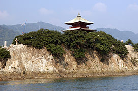
Benten-shima with the Benten-do

Prayer hall ( haiden ) of the Nunakuma Shrine


Islands
The marine area includes the following six islands. The islands are now uninhabited, although Sensui-jima still had inhabitants in 1995.
| Surname | Japanese | Area [km²] | Height [m] | Coordinates |
|---|---|---|---|---|
| Sensui-jima | 仙 酔 島 | 0.92 | 158.7 | 34 ° 22 '58 " N , 133 ° 23' 49" E |
| Kogō-shima | 皇后 島 | 0.015 | 30th | 34 ° 22 '50 " N , 133 ° 23' 24" E |
| Tamatsu-shima | 王 津 島 | 0.010 | 15th | 34 ° 22 ′ 33 " N , 133 ° 22 ′ 49" E |
| Benten-jima | 弁 天 島 | 0.002 | ? | 34 ° 22 ′ 59 " N , 133 ° 23 ′ 11" E |
| Tsutsuji-shima | つ つ じ 島 | 0.006 | 25th | 34 ° 22 ′ 44 " N , 133 ° 24 ′ 21" E |
| Tsugaru-shima | 津 軽 島 | 0.006 | ? | 34 ° 22 ′ 9 " N , 133 ° 22 ′ 30" E |
|
|
||||
The Kasaoka Islands are to the east, the Hashirijima Islands to the southeast and the Bingojima Islands to the west - on the opposite side of the peninsula .
Web links
Individual evidence
- ↑ 鞆 の 浦 . In: 知 恵 蔵 2015 at kotobank.jp. Retrieved March 12, 2015 (Japanese).
- ↑ 鞆 の 浦 . In: Daijisen. Retrieved March 12, 2015 (Japanese).
- ↑ a b 「鞆 の 浦 慕 情」 ゆ か り の ス ポ ッ ト . Fukuyama City, accessed March 12, 2015 (Japanese).
- ↑ 広 島 県 の 文化 財 - 沼 名 前 神社 能 舞台 . Hiroshima Prefecture, accessed March 13, 2015 (Japanese).
- ↑ 広 島 県 の 文化 財 - 安 国寺 釈 迦 堂 . Hiroshima Prefecture, accessed March 12, 2015 (Japanese).
- ↑ 15 昭和 28 年 2 月 島嶼 . (No longer available online.) Hiroshima Prefecture, 1953, formerly the original ; Retrieved March 12, 2015 (Japanese). ( Page no longer available , search in web archives ) Info: The link was automatically marked as defective. Please check the link according to the instructions and then remove this notice.
- ↑ 広 島 県 の し ま っ ぷ . Japanese Coast Guard, accessed March 12, 2015 (Japanese).
- ↑ in the historical source 仙 醉 島
- ↑ 仙 酔 島 (せ ん す い じ ま) . In: 日本 の 島 へ 行 こ う . Retrieved March 12, 2015 (Japanese, The Coast Guard Source states 0.83km² (827860.1m²), but most other sources (including the Daijisen) state 0.9km², so this size seems more plausible.).
- ↑ in the historical source 辨 天 島
- ↑ in the historical source 躑躅 島
Coordinates: 34 ° 22 ′ 45 ″ N , 133 ° 23 ′ 0 ″ E