Tongue Bay
| Tongue Bay | ||
|---|---|---|
|
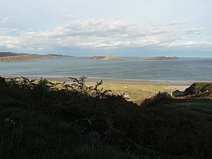
Tongue Bay seen from the southeast. In the center of the picture: The Rabbit Islands |
||
| Waters | Atlantic Ocean | |
| Land mass | Great Britain (island) | |
| Geographical location | 58 ° 31 '48 " N , 4 ° 23' 24" W | |
|
|
||
| width | approx. 4 km | |
| depth | approx. 3 km | |
| Islands | Rabbit Islands, Eilean nan Ròn | |
Tongue Bay ( Scottish Gaelic : Tunga) is a bay in northern Scotland . It is located in the former county of Sutherland in the Highland Council Area . The bay is about 4 km wide and extends about 3 km inland. At its landside end, the bay merges into the much flatter Kyle of Tongue , which extends another 10 km inland. The bay, the Kyle of Tongue and the surrounding area form one of Scotland's 40 National Scenic Areas .
In the bay are the three uninhabited Rabbit Islands. Immediately in front of the bay is the island of Eilean nan Ròn , which means the island of the seals . Eilean nan Ròn is also uninhabited today, but until 1938 it housed a small settlement, ruins of which can still be seen today.
The area around Tongue Bay is very sparsely populated. With the village of Talmine to the west of the bay , which consists of only a few farmsteads, there is only a smaller settlement near the shore. In Talmine also the only significant sandy beach of the Bay is located. Most of the other stretches of coastline are rocky.

