Trans Sumatra Highway
The Trans-Sumatra-Highway ( Indonesian : Jalan Raya Lintas Sumatra , in German: Trans-Sumatra-Fernstraße. Also the form Trans-Sumatran-Highway is in use) is an approx. 2500 km long road across the Indonesian island of Sumatra .
The road is also called the Asian Highway AH25 . The linking of the local individual routes to a continuous road began in the late 1970s and ended in the early 1980s. Even if some parts of the route, as with Medan , are built like a motorway, it is mostly a simple country road that works its way up in mountainous areas in tight serpentines .
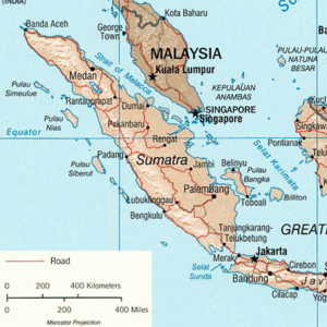
The road connects Banda Aceh on the northern tip of Sumatra via Medan, Prapat , Bukittinggi , Sibolga , Padang , Lubuk Linggau , Martapura and Kotabumi with Bandar Lampung and Bakauheni on the southern tip. Across the Sunda Strait , the traffic route continues in Merak on the neighboring island of Java .
For the route from Bakauheni to Padang, a bus journey of 36 hours is expected, but it can also take up to 48 hours.
The construction has pushed the development of Sumatra and made previously inaccessible areas accessible. However, this now also enables the exploitation and destruction of previously untouched nature. Forest fires, logging and agricultural use are increasingly displacing the original rainforest.
