Lubuk Linggau
Coordinates: 3 ° 18 ′ S , 102 ° 52 ′ E
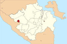
Lubuk Linggau is an Indonesian city in the south of the island of Sumatra , belongs to the Sumatra Selatan Province (South Sumatra) and is located west of the provincial capital Palembang . The city has 200,481 inhabitants (2010 calculation), an area of 401.50 km² and is at an altitude of 129 m.
The city is located on the Trans-Sumatra Highway , which runs across Sumatra from Bakauheni in the south to Banda Aceh in the north. It borders on the province of Bengkulu in the southwest .
The city is divided into 8 Kecamatan (sub-districts) and 72 Kelurahan . The sub-districts are:
- Lubuklinggau Barat I
- Lubuklinggau Barat II
- Lubuklinggau Selatan I
- Lubuklinggau Selatan II
- Lubuklinggau Timur I
- Lubuklinggau Timur II
- Lubuklinggau Utara I
- Lubuklinggau Utara II
Web links
- www.lubuklinggau.go.id Website of the city (Indonesian)
Individual evidence
- ↑ Archived copy ( Memento of the original dated December 29, 2011 in the Internet Archive ) Info: The archive link was automatically inserted and not yet checked. Please check the original and archive link according to the instructions and then remove this notice.

