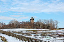
Trendelberg
The Trendelberg is a small elevation north of the town of Haldensleben in Saxony-Anhalt .
The mountain reaches a height of 76.6 meters. Together with the Detzel mountains to the north-west, it forms a small ridge that forms the eastern boundary of the Ohre valley . The water tower on the Trendelberg was built near its summit in 1910 . There is a small wood in the area around the water tower. The town's Jewish cemetery was built at the foot of the mountain in 1811 .
The road from Haldensleben to Satuelle leads south-west of the mountain, and east along the road from Haldensleben towards Salzwedel . The extensive forest areas of the Colbitz-Letzlinger Heide stretch north of the Trendelberg .
In the 1930s to 1940s, the area at the water tower was used, among other things, with the SG 38 for gliding and gliding training.
Coordinates: 52 ° 18 ' N , 11 ° 25' E
