
Trillkebach
| Trillkebach | ||
 Map around 1770 (edited) |
||
| Data | ||
| location | in Hildesheim ; District of Hildesheim , Lower Saxony ( Germany ) | |
| River system | Weser | |
| Drain over | Copper strand → Innerste → Leine → Aller → Weser → North Sea | |
| origin | Pond with several tributaries at Marienrode Abbey 52 ° 6 ′ 49 ″ N , 9 ° 55 ′ 7 ″ E |
|
| confluence | in Moritzberg with the Blänkebach to the copper strand Coordinates: 52 ° 8 '51 " N , 9 ° 55' 57" E 52 ° 8 '51 " N , 9 ° 55' 57" E
|
|

The Trillkebach , often called Trillke for short , rises southwest of Hildesheim from three spring strands near Marienrode and from the slopes in the southern part of the Steinberg. In the Moritzberg district , near the Königsteich, it joins the Blänkebach to form the Kupferstrang , which flows into the innermost part of the Steuerwald district .
The Trillkebach in Hildesheim was first mentioned in a document in 1288 as the “Trildane”. In 1380, Bishop Gerhard had the Trillkebach dammed, so that the Neue Teich was created, which is reminiscent of the street name Am Neuen Teiche . Its approximate location can still be seen in places to the east of Moritzberger Weg and Am Probsteihof street . The Steinbergstraße, next to which the Trillke flows in parts, has been called "deep road" since 1523 because of its course deep between Steinberg and Katzberg. It did not get its current name until 1901. In the area where it now runs over the Trillke (at the level of the forest spring ), there was originally a passage through the stream instead of a bridge.
The course of the Trillkebach was changed several times. In 1866 it was moved to today's Küchenthalstrasse. After the devastating March floods of 1947, work on straightening and regulating Trillke, Blänkebach and Kupferstrang was carried out again from 1950 to 1952 .
Picture gallery
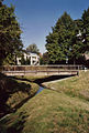
The Trillkebach flows over a length of around 500 m in the middle of Küchenthalstrasse.
Confluence of the Trillke- (left) and Blänkebach (right) in Hildesheim- Moritzberg

The copper strand that Trillkebach and Blänkebach unite to form

Trillkebach east of Hildesheim- Neuhof at the level of the street "Schwarze Riede"

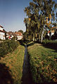
Trillkebach in Hildesheim, between Gerlandstrasse and Steinbergstrasse


